Crookedwood
Tigh Munna | |
|---|---|
Village | |
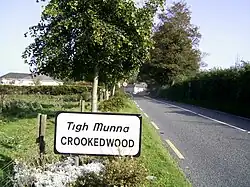
 Road signage on the approach to Crookedwood | |
 Crookedwood Location in Ireland | |
| Coordinates: 53°36′08″N 7°17′34″W / 53.6023°N 7.2927°W | |
| Country | Ireland |
| Province | Leinster |
| County | County Westmeath |
| Elevation | 118 m (387 ft) |
| Time zone | UTC+0 (WET) |
| • Summer (DST) | UTC-1 (IST (WEST)) |
| Irish Grid Reference | N465616 |
Crookedwood (Irish: Tigh Munna) is a small village in County Westmeath on the R394 regional road. Historically it was called Taghmon (Irish: Tigh Munna), after the townland it occupies.[1]
Geography
Overlooked by the dominating hill of Knockeyon to the north, the village rests between the pine-covered hills as they roll down towards Lough Derravaragh, and located about 8 km north of Mullingar, at the south-eastern tip of the Lough.
Similar to Lough Lene, in Collinstown, the nearby Lough Derravaragh fishing interests are also promoted by the Crookedwood community.
Transport
Bus Éireann route 447 provides a link to Mullingar on Thursdays only.[2] The nearest rail service can be accessed at Mullingar railway station approximately 11km distant.
Sport
The local hurling club, Crookedwood G.A.A, play in the Senior B division of the Westmeath hurling championship.[3]
See also
References
- ↑ Placenames Database of Ireland (see archival records)
- ↑ "Timetable - Route 447" (PDF). Archived from the original (PDF) on 25 October 2012. Retrieved 18 May 2013.
- ↑ "Senior B Hurling Championship 2022". Westmeath GAA. Retrieved 19 February 2023.

