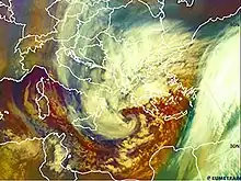
 Subtropical Cyclone Julia on February 7, about a day after peak intensity. | |
| Formed | February 2, 2012 |
|---|---|
| Dissipated | February 11, 2012 |
| Highest winds |
|
| Lowest pressure | 982 mb (29.00 inHg) |
| Fatalities | At least 12 |
| Damage | > $6.4 million (2012 USD) |
| Areas affected | Central Europe, Eastern Europe, France, Italy, Crete, Cyprus, North Africa, Levant, Turkey |
Cyclone Julia (also known as Medicane Julia) brought heavy flooding and hurricane conditions to parts of Europe, the Mediterranean region, and North Africa in February 2012. The second tropical or subtropical cyclone, second named storm, and the strongest storm of the 2011–12 Mediterranean hurricane season, Julia originated from an extratropical system that split off from its parent storm, in the western Mediterranean Sea on February 2. Despite the unfavorable conditions in the Mediterranean Sea, Julia strengthened into a powerful subtropical cyclone, with winds peaking at 61 mph (98 km/h), and a minimum pressure of 982 mbar (29.0 inHg) on February 6. On February 7, the storm made landfall on the Peloponnesian Peninsula, and eventually dissipated over Turkey. Cyclone Julia caused at least $6.4 million (2012 USD) in damages, and resulted in at least 12 deaths.[1] The storm also worsened the effects of the Early 2012 European cold wave across Europe and North Africa.
Meteorological history
On January 31, 2012, an extratropical storm developed over western France, which was named Julia by the Free University of Berlin.[2] Within the next couple of days, the storm moved quickly southeastward into the Mediterranean Sea, but the system split in half on February 2, with the new low pressure center developing off the east coast of Spain, which was subsequently identified as Julia II.[3] Over the next couple of days, Julia II moved westward while strengthening, before absorbing the original low pressure area of Julia I on February 4, near Italy.[4][5] The storm weakened while passing to the south of Italy,[6] before reorganizing on February 6.[7] Afterward, Julia began to rapidly intensify, reaching peak intensity late on February 6, with a minimum low pressure of 982 mbar (29.0 inHg) and peak sustained winds at 61 mph (98 km/h).[8] Around the same time, the system briefly lost its cold front, and became a powerful subtropical storm. On February 7, Julia began to weaken and regained its frontal system, as the storm moved towards the Peloponnese. Later on the same day, Julia made landfall on the Peloponnese, bringing hurricane-force wind gusts and torrential rainfall.[8][9] After landfall, Julia rapidly weakened, with the system becoming disorganized, while gradually moving eastward.[10] On February 9, Julia made landfall in Turkey and began to accelerate eastward, while continuing to weaken.[11][12] Julia continued to accelerate eastward over the next couple of days, before being absorbed into another extratropical system on February 11.[13]
Preparations and impact

On December 16, 2011, the NOAA had ceased monitoring storms in the Mediterranean Sea, possibly due to economic reasons and budget cuts.[14] At the time of Julia's existence, no tropical cyclone agencies were known to be monitoring the system, possibly because the storm did not exist within any established basins' area of responsibility; only European weather agencies and the University of Berlin were known to have tracked the storm.
The system brought powerful tropical storm-force winds and hurricane-force gusts to parts of Italy, Crete, Greece. In addition, the storm brought heavy rainfall to widespread areas across Europe, Turkey, and North Africa, causing at least $6.4 million dollars and damages, and killing 12 people in Greece and Bulgaria.[8][1] In Bulgaria and Greece, heavy rainfall from Julia, coupled with melting snow, triggered widespread flooding, and many rivers overflowing their banks. Bulgaria suffered the most damage from the storm, with $4.4 million alone incurred from losses in the country. Additionally, the Ivanovo Dam in Bulgaria burst during the deluge, flooding the village of Bisser downstream with 2.5 meters (8 feet) of water. In Bulgaria, the city of Svilengrad was also flooded after a dike collapsed near the village of Generalovo.[1] In Greece, the hardest-hit areas were located in the northeast of the country, where Evros River burst its banks and submerged multiple villages.[1] Cyclone Julia also worsened the effects of a major cold wave across Europe and North Africa, leading to more property damage and deaths. The storm's heavy snow caused 100 kilometres (62 mi) of the Danube River to freeze.[15]
See also
References
- 1 2 3 4 "February 2012 Global Catastrophe Recap" (PDF). Aon Benfield. p. 5. Archived from the original (PDF) on October 16, 2013. Retrieved March 30, 2012.
- ↑ Europe Weather Analysis on 2012-01-31
- ↑ Europe Weather Analysis on 2012-02-02
- ↑ Europe Weather Analysis on 2012-02-03
- ↑ Europe Weather Analysis on 2012-02-04
- ↑ Europe Weather Analysis on 2012-02-05
- ↑ Europe Weather Analysis on 2012-02-06
- 1 2 3 Kyriati Metheneti (February 7, 2012). "A case of rapid cyclogenesis over Ionian Sea on February 6th, 2012" (PDF). EUMETSAT. Retrieved January 31, 2021.
- ↑ Europe Weather Analysis on 2012-02-07
- ↑ "Europe Weather Analysis on 2012-02-08". Archived from the original on 2016-03-04. Retrieved 2017-09-23.
- ↑ Europe Weather Analysis on 2012-02-09
- ↑ Europe Weather Analysis on 2012-02-10
- ↑ Europe Weather Analysis on 2012-02-11
- ↑ "Mediterranean Sea Bulletin - 16 Dec 2011". National Environmental Satellite, Data, and Information Service (NESDIS). NOAA Satellite and Information Service. 16 December 2011. Retrieved 25 May 2019.
- ↑ "Snow cuts off hundreds of villages in eastern Europe". Reuters. February 7, 2012. Retrieved September 13, 2022.
External links
- Rapid Cyclogenesis over Ionian Sea cancelled all marine activities and caused flooding and structural damage in early February 2012.
- EUMETSAT Cyclone Julia report
- Info on a possible 1995 event
- Official website
- EUMETSAT weather satellite viewer
- Website monitoring Medicane activity Archived 2013-12-22 at the Wayback Machine
- Scientific article about Medicanes
- Mediterranean Sea Surface Weather Analysis Archive Maps