Dąbrowa | |
|---|---|
Village | |
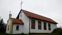
 Catholic chapel in Dąbrowa | |
 Dąbrowa | |
| Coordinates: 54°17′N 19°53′E / 54.283°N 19.883°E | |
| Country | |
| Voivodeship | |
| County | Braniewo |
| Gmina | Płoskinia |
| Vehicle registration | NBR |
Dąbrowa [dɔmˈbrɔva] is a village in the administrative district of Gmina Płoskinia, within Braniewo County, Warmian-Masurian Voivodeship, in northern Poland.[1] It lies approximately 4 kilometres (2 mi) north-west of Płoskinia, 12 km (7 mi) south of Braniewo, and 69 km (43 mi) north-west of the regional capital Olsztyn.
Dąbrowa formed part of Poland until the First Partition of Poland in 1772, when it was annexed by Kingdom of Prussia, and from 1871 to 1945 it was also part of Germany, where it was administratively located in the province of East Prussia. After Germany's defeat in World War II, the village became again part of Poland.
References
This article is issued from Wikipedia. The text is licensed under Creative Commons - Attribution - Sharealike. Additional terms may apply for the media files.