Majuro Atoll map
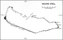
Delap (also called Dalap;[1] Marshallese: Teļap, [tˠɛːlˠɑpʲ][2]) is an island district in the Marshall Islands. It is located in the east of Majuro Atoll. Along with Uliga and Djarrit it forms what is known as the "Delap-Uliga-Djarrit".
During World War II was the site of a large base, Naval Base Majuro.[3][4]
See also
References
- ↑ Sabath, Michael D. (October 1977). "Vegetation and Urbanization on Majuro Atoll, Marshall Islands" (PDF). Pacific Science. 31 (4): 325–326, 331. ISSN 0030-8870. Retrieved 10 September 2023.
- ↑ Marshallese-English Dictionary - Place Name Index
- ↑ "Marshall Islands -- Building the Navy's Bases -- Majuro Naval Base". marshall.csu.edu.au.
- ↑ Majuro Atollpacificwrecks.com
This article is issued from Wikipedia. The text is licensed under Creative Commons - Attribution - Sharealike. Additional terms may apply for the media files.