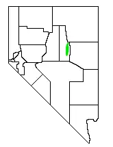
| Diamond Valley | |
|---|---|
| Geography | |
| Country | United States |
| State | Nevada |
| Coordinates | 39°45′33″N 115°58′23″W / 39.7592°N 115.973°W |

Diamond Valley is a valley basin between the Sulphur Spring Range and the Diamond Mountains, in central Nevada, the Western United States.
Geography

The valley is almost entirely within Eureka County, but the northern end crosses into Elko County. The valley is up to 12 miles (19 km) wide and over 45 miles (72 km) long.
The town of Eureka lies at the southern end of Diamond Valley, while the northern end is home to an alkali flat. Several small lakes are located in the western part of the valley near Sadler Brown Road. Eureka Airport is also located towards the southern end of the valley.
Climate
| Climate data for Diamond Valley, Nevada, 1991–2020 normals, 1979-2020 extremes: 5890ft (1795m) | |||||||||||||
|---|---|---|---|---|---|---|---|---|---|---|---|---|---|
| Month | Jan | Feb | Mar | Apr | May | Jun | Jul | Aug | Sep | Oct | Nov | Dec | Year |
| Record high °F (°C) | 63 (17) |
68 (20) |
78 (26) |
83 (28) |
92 (33) |
98 (37) |
105 (41) |
99 (37) |
94 (34) |
93 (34) |
75 (24) |
63 (17) |
105 (41) |
| Mean maximum °F (°C) | 54.2 (12.3) |
58.3 (14.6) |
69.7 (20.9) |
76.7 (24.8) |
83.4 (28.6) |
91.9 (33.3) |
96.7 (35.9) |
94.1 (34.5) |
88.0 (31.1) |
80.3 (26.8) |
66.2 (19.0) |
55.8 (13.2) |
96.0 (35.6) |
| Mean daily maximum °F (°C) | 38.7 (3.7) |
42.8 (6.0) |
52.4 (11.3) |
58.6 (14.8) |
67.9 (19.9) |
79.1 (26.2) |
87.1 (30.6) |
85.8 (29.9) |
77.1 (25.1) |
64.2 (17.9) |
49.9 (9.9) |
38.9 (3.8) |
61.9 (16.6) |
| Daily mean °F (°C) | 25.5 (−3.6) |
30.1 (−1.1) |
37.5 (3.1) |
43.1 (6.2) |
51.4 (10.8) |
60.2 (15.7) |
67.8 (19.9) |
66.5 (19.2) |
58.2 (14.6) |
46.4 (8.0) |
35.0 (1.7) |
25.4 (−3.7) |
45.6 (7.6) |
| Mean daily minimum °F (°C) | 12.3 (−10.9) |
17.3 (−8.2) |
22.7 (−5.2) |
27.7 (−2.4) |
34.8 (1.6) |
41.4 (5.2) |
48.4 (9.1) |
47.3 (8.5) |
39.2 (4.0) |
28.5 (−1.9) |
20.2 (−6.6) |
12.2 (−11.0) |
29.3 (−1.5) |
| Mean minimum °F (°C) | −11.8 (−24.3) |
−4.0 (−20.0) |
6.0 (−14.4) |
12.5 (−10.8) |
20.7 (−6.3) |
27.7 (−2.4) |
37.1 (2.8) |
34.7 (1.5) |
25.4 (−3.7) |
11.8 (−11.2) |
−1.6 (−18.7) |
−10.1 (−23.4) |
−14.5 (−25.8) |
| Record low °F (°C) | −36 (−38) |
−37 (−38) |
−6 (−21) |
−3 (−19) |
11 (−12) |
20 (−7) |
26 (−3) |
27 (−3) |
13 (−11) |
−1 (−18) |
−18 (−28) |
−34 (−37) |
−37 (−38) |
| Average precipitation inches (mm) | 0.77 (20) |
0.77 (20) |
0.89 (23) |
0.96 (24) |
1.12 (28) |
0.68 (17) |
0.57 (14) |
0.43 (11) |
0.61 (15) |
0.67 (17) |
0.51 (13) |
0.74 (19) |
8.72 (221) |
| Source 1: NOAA[1] | |||||||||||||
| Source 2: XMACIS2 (records & monthly max/mins)[2] | |||||||||||||

Agriculture
Diamond Valley is also known for their farms that grow timothy hay, alfalfa hay, wheat, oats, and orchard grass. The hay provides feed for racetracks, dairies, and feed stores throughout the United States and foreign export market.
References
- ↑ "Diamond Valley - Eureka 14NNW, Nevada 1991-2020 Monthly Normals". Retrieved November 15, 2023.
- ↑ "xmACIS". National Oceanic and Atmospheric Administration. Retrieved November 15, 2023.
- Nevada Atlas & Gazetteer, DeLorme, 2012, pgs. 39 & 47 ISBN 0-89933-334-6
39°45′33″N 115°58′24″W / 39.75917°N 115.97333°W