 | |
| Location | Castine, Maine |
|---|---|
| Coordinates | 44°22′57.6″N 68°49′7.86″W / 44.382667°N 68.8188500°W |
| Tower | |
| Constructed | 1829 |
| Automated | 1937 |
| Shape | Rubble Tower |
| Markings | White |
| Heritage | NRHP contributing property |
| Fog signal | none |
| Light | |
| Deactivated | 1937-2008 |
| Focal height | 134 feet (41 m) |
| Range | 11 nautical miles (20 km; 13 mi) |
| Characteristic | Fl W 6s |
Dyce Head Light | |
| Part of | Castine Historic District |
| NRHP reference No. | 73000240[1] |
| Added to NRHP | February 23, 1973 |
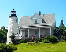
Dyce Head Light is a lighthouse in the town of Castine, Maine.[2][3] First established in 1829, the light was deactivated in 1937 and replaced by a skeleton tower 475 feet (145 m) to the south. When that structure was destroyed by a storm in 2007, however, the old light was reactivated in 2008.[4]
The lighthouse is listed on the National Register of Historic Places as a contributing property to Castine Historic District.[5]
References
- ↑ "National Register Information System". National Register of Historic Places. National Park Service. March 13, 2009.
- ↑ "Historic Light Station Information and Photography: Maine". United States Coast Guard Historian's Office. August 6, 2009. Archived from the original on May 1, 2017.
- ↑ Light List, Volume I, Atlantic Coast, St. Croix River, Maine to Shrewsbury River, New Jersey (PDF). Light List. United States Coast Guard. 2009. p. 32.
- ↑ Rowlett, Russ (August 13, 2009). "Lighthouses of the United States: Eastern Maine". The Lighthouse Directory. University of North Carolina at Chapel Hill.
- ↑ "Inventory of Historic Light Stations - Maine - Dice Head Light". National Park Service. Retrieved August 11, 2009.
Wikimedia Commons has media related to Dice Head Light.
This article is issued from Wikipedia. The text is licensed under Creative Commons - Attribution - Sharealike. Additional terms may apply for the media files.
