| Divide Mountain | |
|---|---|
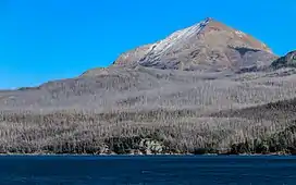 Divide Mountain and Saint Mary Lake | |
| Highest point | |
| Elevation | 8,670 ft (2,640 m)[1] NAVD 88 |
| Prominence | 1,345 ft (410 m)[1] |
| Coordinates | 48°39′55″N 113°24′03″W / 48.66528°N 113.40083°W[2] |
| Geography | |
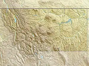 Divide Mountain Location in Montana  Divide Mountain Location in the United States | |
| Location | Glacier County, Montana, U.S. |
| Parent range | Lewis Range |
| Topo map | USGS Saint Mary, MT |
| Climbing | |
| First ascent | Unknown |
| Easiest route | Scramble |
Divide Mountain (8,670 feet (2,643 m)) is located in the Lewis Range, Glacier National Park in the U.S. state of Montana.[3] Divide Mountain is located south of Saint Mary, Montana on the border of Glacier National Park and the Blackfeet Indian Reservation.[4]
Divide Mountain is also notable as the line parent of Mount Mitchell, North Carolina, which is the highest point in the Eastern United States.
See also
Wikimedia Commons has media related to Divide Mountain.
References
- 1 2 "Divide Mountain, Montana". Peakbagger.com. Retrieved June 7, 2018.
- ↑ "Divide Mountain". Geographic Names Information System. United States Geological Survey, United States Department of the Interior. Retrieved June 7, 2018.
- ↑ Saint Mary, MT (Map). TopoQwest (United States Geological Survey Maps). Retrieved June 4, 2018.
- ↑ "Divide Mountain". SummitPost.org. Retrieved 2011-05-09.
This article is issued from Wikipedia. The text is licensed under Creative Commons - Attribution - Sharealike. Additional terms may apply for the media files.