Doskie, Mississippi | |
|---|---|
 Doskie, Mississippi  Doskie, Mississippi | |
| Coordinates: 34°54′21″N 88°17′42″W / 34.90583°N 88.29500°W[1] | |
| Country | United States |
| State | Mississippi |
| County | Tishomingo |
| Elevation | 456 ft (139 m) |
| Time zone | UTC-6 (Central (CST)) |
| • Summer (DST) | UTC-5 (CDT) |
| ZIP code | 38833 |
| Area code | 662 |
Doskie is an unincorporated community[1] located on Mississippi Highway 365 in Tishomingo County, Mississippi, United States. Doskie is just north of the Tennessee–Tombigbee Waterway, approximately 6 miles (9.7 km) north of Burnsville and approximately 13 miles (21 km) northwest of Iuka.[2]
References
Municipalities and communities of Tishomingo County, Mississippi, United States | ||
|---|---|---|
| City | 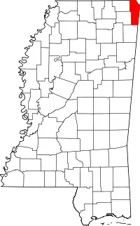 Map of Mississippi highlighting Tishomingo County | |
| Towns | ||
| Village | ||
| CDP | ||
| Other communities | ||
| Ghost town | ||
This article is issued from Wikipedia. The text is licensed under Creative Commons - Attribution - Sharealike. Additional terms may apply for the media files.