| Drumbeg Provincial Park | |
|---|---|
 Map of British Columbia | |
| Location | Nanaimo Land District, British Columbia, Canada |
| Nearest city | Nanaimo, BC |
| Coordinates | 49°07′57″N 123°41′39″W / 49.13250°N 123.69417°W |
| Area | 55 ha. (0.55 km²) |
| Established | 1971 |
| Governing body | BC Parks |
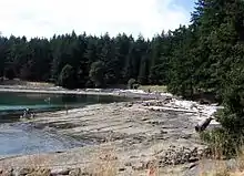
Drumbeg Provincial Park, 2005
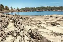
Low tide reveals the eroded sandstone beach at Drumbeg Provincial Park (2017)
Drumbeg Provincial Park is a provincial park on Gabriola Island in British Columbia, Canada.[1][2]
References
- ↑ Drumbeg Provincial Park – BC Parks
- ↑ "Drumbeg Park". BC Geographical Names. Retrieved September 13, 2021.
49°08′02″N 123°41′49″W / 49.134°N 123.697°W
This article is issued from Wikipedia. The text is licensed under Creative Commons - Attribution - Sharealike. Additional terms may apply for the media files.