East Krok, Wisconsin | |
|---|---|
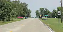
 Looking east in East Krok | |
 East Krok  East Krok | |
| Coordinates: 44°25′44″N 87°36′08″W / 44.42889°N 87.60222°W | |
| Country | |
| State | |
| County | Kewaunee |
| Town | West Kewaunee |
| Elevation | 222 m (728 ft) |
| Time zone | UTC-6 (Central (CST)) |
| • Summer (DST) | UTC-5 (CDT) |
| Area code | 920 |
| GNIS feature ID | 1564340[1] |
Looking east at the sign for East Krok

Looking south in East Krok
East Krok is an unincorporated community in the town of West Kewaunee in Kewaunee County, Wisconsin, United States.[1] Unincorporated Krok is located just west of East Krok and can be accessed via Krok Road.[2]
References
- 1 2 "East Krok". Geographic Names Information System. United States Geological Survey, United States Department of the Interior. Retrieved July 13, 2009.
- ↑ "East Krok Map". United States Geographical Survey. Google. Retrieved July 13, 2009.
Municipalities and communities of Kewaunee County, Wisconsin, United States | ||
|---|---|---|
| Cities | 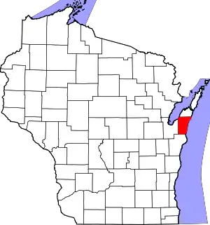 | |
| Villages | ||
| Towns | ||
| CDP | ||
| Unincorporated communities | ||
| Former communities | ||
| Footnotes | ‡This populated place also has portions in an adjacent county or counties | |
This article is issued from Wikipedia. The text is licensed under Creative Commons - Attribution - Sharealike. Additional terms may apply for the media files.