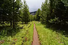
A trail through Echo Valley
Echo Valley is a valley in Yosemite National Park, at an elevation of 7,021 feet (2,140 m).[1] It is located along Echo Creek, about 3 miles (5 km) west of Merced Lake, at 37°44′38″N 119°26′03″W / 37.7438°N 119.4343°W.[1] It is bounded on the south by the Merced River.[2]
The valley contains a mosaic of meadows that are likely related to a fire that burned through the area in the 1980s. This fire killed most of the trees, raising the water table, and creating the meadows. Debris and deadfall from burned trees are common in many of the meadow areas.[2]
References
- 1 2 "Echo Valley". Geographic Names Information System. United States Geological Survey, United States Department of the Interior.
- 1 2
 This article incorporates public domain material from "2010 Assessment of Meadows in the Merced River Corridor" (PDF). Yosemite National Park. National Park Service. Retrieved 2015-01-09.
This article is issued from Wikipedia. The text is licensed under Creative Commons - Attribution - Sharealike. Additional terms may apply for the media files.