Edarikode | |
|---|---|
Town | |
 | |
| Coordinates: 10°59′0″N 75°58′0″E / 10.98333°N 75.96667°E | |
| Country | |
| State | Kerala |
| District | Malappuram |
| Government | |
| • Type | panchayat |
| Population (May 2011) | |
| • Total | 30,000 |
| Language = Malayalam | |
| • Official | Malayalam, English |
| Time zone | UTC+5:30 (IST) |
| PIN | 676501 |
| Telephone code | 0483 |
| Vehicle registration | KL-55,KL-10 |
| Nearest city | kottakkal |
| Lok Sabha constituency | Ponnani |
| Climate | good (Köppen) |
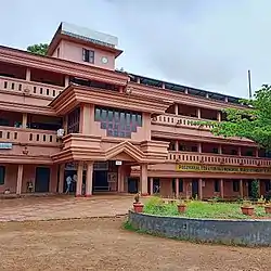
Edarikode is a village Panchayat near the Municipal town of Kottakkal, in Malappuram district of Kerala state. Kottakkal and Edarikode jointly can be treated as Ayurveda Nagara.pkmmhss , gups clari , ysc ground edarikode very famous
Transportation
Edarikkode village connects to other parts of India through Kottakkal town. National highway No.66 passes through Kottakkal and the northern stretch connects to Goa and Mumbai. The southern stretch connects to Cochin and Thiruvananthapuram. State Highway No.28 starts from Nilambur and connects to Ooty, Mysore and Bangalore through Highways.12,29 and 181. National Highway No.966 connects to Palakkad and Coimbatore.
- Railway Station: Tirur railway station is one of the major railway stations in the Malabar region. Almost every train stops here, connecting the Malappuram district to the rest of the country.
- Nearest Airport: Calicut International Airport is approximately 25 kilometres away.
References
This article is issued from Wikipedia. The text is licensed under Creative Commons - Attribution - Sharealike. Additional terms may apply for the media files.