The Malappuram district has four types of administrative hierarchies:
- Taluk and Village administration managed by the provincial government of Kerala
- Panchayath Administration managed by the local bodies
- Municipal administration managed by the urban local bodies.
- Parliament Constituencies for the federal government of India
- Assembly Constituencies for the provincial government of Kerala
.svg.png.webp)
Civic administration
.svg.png.webp)
Being the headquarters city, Malappuram comprises the Civil Station area which consists of administrative and other Government offices of the district such as District Collectorate, District Treasury, RTO, PWD Division Office, District Panchayat, Town planning Office, Text depot, District Medical office, etc. to name a few. The city is administered by the Malappuram Municipality, headed by a Municipal Chairman. For administrative purposes, the city is divided into 40 wards, from which the members of the municipal council are elected for five years. The Chairman of Malappuram Municipality is Sri mujeeb Kaderi (IUML) and the Deputy Chairperson is Sri. Konnola fousiya (INC). The present Malappuram District Collector is K. Gopalakrishnan.[1]
ISO Certification
Malappuram is the first municipal body in India to win an ISO 9001-2008 certification for quality management. It has been on a track of fast reforms for the past couple of years and has achieved the distinction of having zero pendency of files.[2]
Law and order
City police is headed by a DySP (Deputy Superintendent of police) of Malappuram. And Office of Superintendent of Police is also at Malappuram. Apart from regular law and order, city police comprise the Malappuram Traffic Police, Bomb Squad, Dog Squad, Women's Cell, Narcotics Cell, Malabar Special Police, Armed Police Camp, District Crime Records Bureau.[3][4]
Proposed Malappuram Municipal Corporation
There is a demand to upgrade Malappuram Municipality to a Municipal Corporation by incorporating the local bodies in the Greater Malappuram region.[5] The proposed Malappuram Municipal Corporation comprises:
- Malappuram Municipality
- Manjeri Municipality
- Kottakkal Municipality
- Anakkayam Outgrowth.
- Trikkalangode, a suburb village of Manjeri
- Koottilangadi, a suburb village of Malappuram
- Pookkottur, a suburb village of Malappuram
- Kodur, a suburb village of Malappuram
- Ponmala, a suburb village of Malappuram
- Othukkungal, an outgrowth of Malappuram
- Makkaraparamba
Political Divisions
The federal, provincial and local administration of Malappuram district has a complex structure.
Legislative Assembly constituencies
| Sl.no | Constituency | Reserved for (SC/ST/None) |
Local segments | Member of the 15th Niyamasabha |
Party | Alliance |
|---|---|---|---|---|---|---|
| 33 | Kondotty | None | T. V. Ibrahim | IUML | UDF | |
| 34 | Eranad | None | P. K. Basheer | IUML | UDF | |
| 35 | Nilambur | None | P. V. Anvar | Independent | LDF | |
| 36 | Wandoor | SC | A. P. Anil Kumar | INC | UDF | |
| 37 | Manjeri | None | U. A. Latheef | IUML | UDF | |
| 38 | Perinthalmanna | None | Najeeb Kanthapuram | IUML | UDF | |
| 39 | Mankada | None | Manjalamkuzhi Ali | IUML | UDF | |
| 40 | Malappuram | None | P. Ubaidulla | IUML | UDF | |
| 41 | Vengara | None | List |
P. K. Kunhalikutty | IUML | UDF |
| 42 | Vallikunnu | None | P. Abdul Hameed | IUML | UDF | |
| 43 | Tirurangadi | None | K. P. A. Majeed | IUML | UDF | |
| 44 | Tanur | None | V. Abdurahiman | INL | LDF | |
| 45 | Tirur | None | Kurukkoli Moideen | IUML | UDF | |
| 46 | Kottakkal | None | K. K. Abid Hussain Thangal | IUML | UDF | |
| 47 | Thavanur | None | K. T. Jaleel | Independent | LDF | |
| 48 | Ponnani | None | P. Nandakumar | CPI(M) | LDF |
Parliament constituencies
| Parliamentary constituency | Assembly constituencies | MP | Political party |
|---|---|---|---|
| Malappuram | Malappuram, Manjeri, Mankada, Perinthalmanna, Vallikunnu, Kondotty and Vengara. | M. P. Abdussamad Samadani | IUML |
| Ponnani (Major portion) | Tirurangadi, Tirur, Tanur, Ponnani, Kottakkal and Thavanur. | E. T. Mohammed Basheer | IUML |
| Wayanad (Minor portion) | Eranad, Wandoor and Nilambur. | Rahul Gandhi | INC |
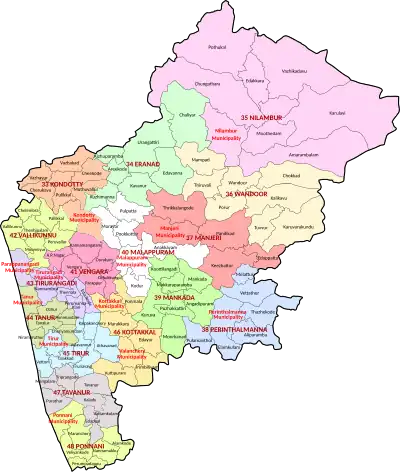
Administrative subdivisions
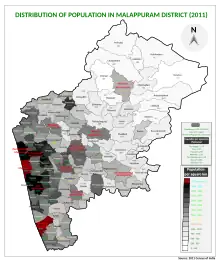
The district consists of two revenue divisions (Tirur and Perintalmanna), seven subdistricts, 135 villages, 15 blocks, twelve municipalities and 100 panchayats.
Revenue administration
For the ease of revenue administration, there are 7 subdistricts in the district, which are again divided into 138 villages. These 7 subdistricts are combined in 2 revenue divisions namely Tirur and Perinthalmanna.
| Subdistrict | Area (in km2) |
Population (2011) |
Villages | |
|---|---|---|---|---|
| Ponnani | 200 | 379,798 | 11 | |
| Tirur | 448 | 928,672 | 30 | |
| Tirurangadi | 290* | 631,906* | 17 | |
| Kondotty | 254* | 410,577* | 12 | |
| Eranad | 491* | 581,512* | 23 | |
| Perinthalmanna | 506 | 606,396 | 24 | |
| Nilambur | 1,343 | 574,059 | 21 | |
| Sources: 2011 Census of India,[6] Official website of Malappuram district[7] | ||||
Ponnani, Tirur, Tirurangadi, and Kondotty are included in the Tirur revenue division, whereas the remaining Taluks together form Perinthalmanna revenue division.
Rural administration
.svg.png.webp)
For the ease of rural administration, the rural district is divided into 94 Gram Panchayats which together form 15 blocks.[8] These 15 block panchayats combine to form the Malappuram district Panchayat, which is the apex body of rural governance in the district. The 94 Gram Panchayats are again divided into 1,778 wards.[9] However, Census towns (small towns with urban features) also come under the jurisdiction of Gram Panchayats.
Urban administration
For the ease of urban administration, 12 municipalities are there in the district.
| No. | Municipal town | Taluk | Images | No. | Municipal town | Taluk | Images | ||
|---|---|---|---|---|---|---|---|---|---|
| 1 | Ponnani | Ponnani | 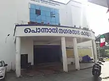 |
7 | Tirurangadi | Tirurangadi | .jpg.webp) | ||
| 2 | Manjeri | Eranad | 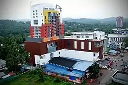 |
8 | Tirur | Tirur | 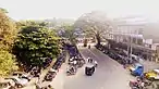 | ||
| 3 | Parappanangadi | Tirurangadi |  |
9 | Perinthalmanna | Perinthalmanna |  | ||
| 4 | Tanur | Tirur | 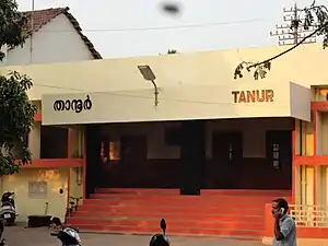 |
10 | Nilambur | Nilambur | 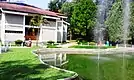 | ||
| 5 | Malappuram | Eranad |  |
11 | Valanchery | Tirur |  | ||
| 6 | Kondotty | Kondotty |
|
12 | Kottakkal | Tirur |  | ||
| Source:[10][11] | |||||||||
| Municipality[12] | Wards[13] | Population (2011)[14] |
Chairperson [15] | Political Party |
Pre-poll Alliance | |
|---|---|---|---|---|---|---|
| 1 | Manjeri | 50 | 97,102 | V. M. Subaida | IUML | UDF |
| 2 | Ponnani | 51 | 90,491 | Sivadasan Attupurath | CPI(M) | LDF |
| 3 | Parappanangadi | 45 | 71,239 | A. Usman | IUML | UDF |
| 4 | Tanur | 44 | 69,534 | P. P. Shamsudheen | IUML | UDF |
| 5 | Malappuram | 40 | 68,088 | Mujeeb Kaderi | IUML | UDF |
| 6 | Kondotty | 40 | 59,256 | Fathimath Suhrabi. C. T | IUML | UDF |
| 7 | Tirurangadi | 39 | 56,632 | K. P. Muhammad Kutty | IUML | UDF |
| 8 | Tirur | 38 | 56,058 | Naseema | IUML | UDF |
| 9 | Perinthalmanna | 34 | 49,723 | P. Shaji | CPI(M) | LDF |
| 10 | Kottakkal | 32 | 48,342 | Bushra Shabeer | IUML | UDF |
| 11 | Nilambur | 33 | 46,342 | Mattummal Saleem | CPI(M) | LDF |
| 12 | Valanchery | 33 | 44,437 | Ashraf Ambalathingal | IUML | UDF |
See also
References
- ↑ Staff Reporter (27 May 2020). "New Malappuram Collector takes charge". Keralakoumudi. Retrieved 1 July 2020.
- ↑ Staff Reporter (24 February 2014). "First-in-India ISO tag for Malappuram". The Hindu. Retrieved 28 July 2015.
- ↑ Malappuram Police
- ↑ "Archived copy". Archived from the original on 13 August 2016. Retrieved 3 August 2020.
{{cite web}}: CS1 maint: archived copy as title (link) - ↑ "Proposed Malappuram Municipal Corporation". timesofindia.indiatimes.com. 16 May 2014. Retrieved 29 June 2020.
- ↑ "Taluk-wise demography of Malappuram" (PDF). censusindia.gov.in. Directorate of Census Operations, Kerala. pp. 161–193. Retrieved 19 April 2020.
- ↑ "Villages in Malappuram". malappuram.nic.in. Retrieved 25 November 2019.
- ↑ "Rural administration in Malappuram district". Official website of Malappuram district. Retrieved 2 August 2020.
- ↑ "Gram Panchayats and wards in Malappuram". Local self government department, Government of Kerala. Retrieved 3 August 2020.
- ↑ "Municipalities in Malappuram". malappuram.nic.in. Retrieved 1 December 2019.
- ↑ "No. of wards in Malappuram". lsgkerala.gov.in.
- ↑ "Municipalities in Malappuram". malappuram.nic.in. Retrieved 1 December 2019.
- ↑ "No. of wards in Malappuram". lsgkerala.gov.in.
- ↑ "Population of urban bodies" (PDF). Urban Affairs Kerala. Retrieved 14 August 2020.
- ↑ "Chairpersons of municipalities in Malappuram". lsgkerala.gov.in. Government of Kerala. Retrieved 20 February 2021.

