2016 Landsat image of Egg Hill

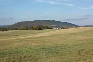
Egg Hill, viewed facing north from Route 322
Egg Hill is an elongate hill trending northeast–southwest in southern Centre County, Pennsylvania.[1] It is mostly forested and uninhabited. Sinking Creek flows northeastward along the northern foot of Egg Hill. The town of Spring Mills is located at the northeastern end.[2]
The historic Egg Hill Church is located at the southwestern end of the hill.
Geology
The crest of Egg Hill is along the axis of a minor syncline, within the larger Nittany Anticlinorium. The bedrock along the axis is the Ordovician Bald Eagle Formation, which is mostly sandstone.[3] The crest of the hill is over 1,900 feet (580 m) elevation.
References
Wikimedia Commons has media related to Egg Hill, Pennsylvania.
- ↑ U.S. Geological Survey Geographic Names Information System: Egg Hill
- ↑ Spring Mills, PA, 7.5' Topographic Quadrangle Map, 2016. USGS. Scale 1:24,000.
- ↑ Berg, T.M., Edmunds, W.E., Geyer, A.R. and others, compilers, (1980). Geologic Map of Pennsylvania: Pennsylvania Geologic Survey, Map 1, scale 1:250,000.
This article is issued from Wikipedia. The text is licensed under Creative Commons - Attribution - Sharealike. Additional terms may apply for the media files.