Eichberg-Trautenburg | |
|---|---|
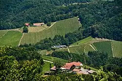 View from the observation tower Kreuzbergwarte (Eichberg-Trautenburg) on Hoehenweg-Karnerberg at Kranach | |
 Coat of arms | |
 Eichberg-Trautenburg Location within Austria | |
| Coordinates: 46°42′00″N 15°26′00″E / 46.70000°N 15.43333°E | |
| Country | Austria |
| State | Styria |
| District | Leibnitz |
| Government | |
| • Mayor | Peter Tschernko (ÖVP) |
| Area | |
| • Total | 21.2 km2 (8.2 sq mi) |
| Elevation | 480 m (1,570 ft) |
| Population (1 January 2016)[1] | |
| • Total | 773 |
| • Density | 36/km2 (94/sq mi) |
| Time zone | UTC+1 (CET) |
| • Summer (DST) | UTC+2 (CEST) |
| Postal code | 8452, 8453, 8454, 8463 |
| Area code | 03454 |
| Vehicle registration | LB |
| Website | www.eichberg-trautenburg.at |
Eichberg-Trautenburg is a former municipality in the district of Leibnitz in the Austrian state of Styria. Since the 2015 Styria municipal structural reform, it is part of the municipality Leutschach an der Weinstraße.[2]
Population
| Year | Pop. | ±% |
|---|---|---|
| 1869 | 1,131 | — |
| 1880 | 1,164 | +2.9% |
| 1890 | 1,141 | −2.0% |
| 1900 | 1,161 | +1.8% |
| 1910 | 1,173 | +1.0% |
| 1923 | 1,102 | −6.1% |
| 1934 | 1,242 | +12.7% |
| 1939 | 1,157 | −6.8% |
| 1951 | 1,183 | +2.2% |
| 1961 | 1,106 | −6.5% |
| 1971 | 1,015 | −8.2% |
| 1981 | 992 | −2.3% |
| 1991 | 897 | −9.6% |
| 2001 | 886 | −1.2% |
| 2011 | 787 | −11.2% |
References
This article is issued from Wikipedia. The text is licensed under Creative Commons - Attribution - Sharealike. Additional terms may apply for the media files.