50°06′29″N 8°40′56″E / 50.1081°N 8.6822°E
Eiserner Steg | |
|---|---|
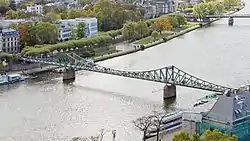
 Aerial view of the Eiserner Steg in 2010 | |
| Coordinates | 50°06′29″N 8°40′56″E / 50.1081°N 8.6822°E |
| Carries | pedestrians |
| Crosses | Main (river) |
| Locale | Frankfurt Altstadt, Sachsenhausen (river kilometer 35.26) |
| Characteristics | |
| Design | Footbridge |
| Material | Iron |
| Total length | 173.59 m (569.5 ft) |
| Width | 5.44 m (17.8 ft) |
| History | |
| Construction start | 1868 |
| Construction end | 1869 |
| Inaugurated | 29 September 1869 |
| Rebuilt | 1946 |
| Destroyed | 25 March 1945 |
| Location | |

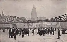
Two years after the renovation in January 1914
The Eiserner Steg (Iron Footbridge) is a footbridge spanning the river Main in the city of Frankfurt, Germany, which connects the centre of Frankfurt with the district of Sachsenhausen.
The first wrought iron bridge was built in 1868.[1][2] It was replaced in 1911/1912 by a slightly larger cantilever bridge.[3] It is 170 metres long and consists of riveted steel trusses with two bridge piers. The bridge was blown up by the Wehrmacht in the final days of World War II, but it was rebuilt shortly afterwards in 1946. It was fully renovated in 1993.[4]
Bibliography
See also
References
- ↑ "Eiserner Steg wird 150: Crowdfunding für ein Frankfurter Wahrzeichen". FAZ.NET (in German). 28 September 2019. Retrieved 7 March 2022.
- ↑ "Eiserner Steg". Frankfurt Tourismus (in German). Retrieved 7 March 2022.
- ↑ "Jubiläumsfeier: Eiserner Steg in Frankfurt strahlt in ganz besonderem Licht". fnp.de (in German). 29 September 2019. Retrieved 7 March 2022.
- ↑ "Eiserner Steg". FRANKFURT.DE – DAS OFFIZIELLE STADTPORTAL (in German). Retrieved 7 March 2022.
Further reading
- "Frankfurt: Eine Stadt sucht ihre Schlösser". FAZ.NET (in German). 28 September 2016. Retrieved 7 March 2022.
Wikimedia Commons has media related to Eiserner Steg (Frankfurt am Main).
This article is issued from Wikipedia. The text is licensed under Creative Commons - Attribution - Sharealike. Additional terms may apply for the media files.