| El Capitan | |
|---|---|
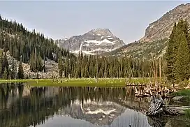
 El Capitan reflected in Little Rock Creek Lake | |
| Highest point | |
| Elevation | 9,984 ft (3,043 m)[1] |
| Prominence | 1,978 ft (603 m)[1] |
| Coordinates | 46°00′27″N 114°23′48″W / 46.0074198°N 114.3967588°W[2] |
| Geography | |
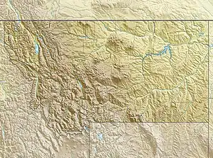
 El Capitan Location in Montana  El Capitan El Capitan (the United States) | |
| Location | Ravalli County, Montana, U.S. |
| Parent range | Bitterroot Range |
| Topo map | USGS El Capitan, MT |
El Capitan is a mountain summit in the Bitterroot Range of Montana. The peak is located in the Selway-Bitterroot Wilderness on land managed by the Bitterroot National Forest. The summit lies 12 miles west of the town of Darby, Montana, and three miles east of the Idaho–Montana border. The highest point of the Central Bitterroot Range is line parent Trapper Peak, 9.3 miles south-southeast.
Climate
Based on the Köppen climate classification, the peak is located in a subarctic climate zone characterized by long, usually very cold winters, and mild summers.[3] Winter temperatures can drop below −10 °F with wind chill factors below −30 °F.
| Climate data for El Capitan (MT) 46.0083 N, 114.3974 W, Elevation: 9,236 ft (2,815 m) (1991–2020 normals) | |||||||||||||
|---|---|---|---|---|---|---|---|---|---|---|---|---|---|
| Month | Jan | Feb | Mar | Apr | May | Jun | Jul | Aug | Sep | Oct | Nov | Dec | Year |
| Mean daily maximum °F (°C) | 24.0 (−4.4) |
23.8 (−4.6) |
28.4 (−2.0) |
34.0 (1.1) |
43.3 (6.3) |
52.1 (11.2) |
64.0 (17.8) |
64.0 (17.8) |
54.6 (12.6) |
40.7 (4.8) |
28.3 (−2.1) |
22.7 (−5.2) |
40.0 (4.4) |
| Daily mean °F (°C) | 17.5 (−8.1) |
16.0 (−8.9) |
19.3 (−7.1) |
23.9 (−4.5) |
32.6 (0.3) |
40.5 (4.7) |
51.0 (10.6) |
50.9 (10.5) |
42.4 (5.8) |
31.0 (−0.6) |
21.7 (−5.7) |
16.4 (−8.7) |
30.3 (−1.0) |
| Mean daily minimum °F (°C) | 10.9 (−11.7) |
8.3 (−13.2) |
10.2 (−12.1) |
13.9 (−10.1) |
21.8 (−5.7) |
29.0 (−1.7) |
37.9 (3.3) |
37.7 (3.2) |
30.3 (−0.9) |
21.2 (−6.0) |
15.0 (−9.4) |
10.1 (−12.2) |
20.5 (−6.4) |
| Average precipitation inches (mm) | 9.25 (235) |
8.91 (226) |
7.75 (197) |
6.96 (177) |
5.53 (140) |
5.63 (143) |
2.22 (56) |
1.76 (45) |
3.39 (86) |
5.91 (150) |
9.63 (245) |
9.92 (252) |
76.86 (1,952) |
| Source: PRISM Climate Group[4] | |||||||||||||
Gallery
References
- 1 2 "El Capitan". Bivouac.com.
- ↑ "Trapper Peak". Geographic Names Information System. United States Geological Survey, United States Department of the Interior.
- ↑ Peel, M. C.; Finlayson, B. L.; McMahon, T. A. (2007). "Updated world map of the Köppen−Geiger climate classification". Hydrol. Earth Syst. Sci. 11: 1633–1644. ISSN 1027-5606.
- ↑ "PRISM Climate Group, Oregon State University". PRISM Climate Group, Oregon State University. Retrieved October 16, 2023.
To find the table data on the PRISM website, start by clicking Coordinates (under Location); copy Latitude and Longitude figures from top of table; click Zoom to location; click Precipitation, Minimum temp, Mean temp, Maximum temp; click 30-year normals, 1991-2020; click 800m; click Retrieve Time Series button.
External links
- El Capitan (photo): Flickr
This article is issued from Wikipedia. The text is licensed under Creative Commons - Attribution - Sharealike. Additional terms may apply for the media files.

