.jpg.webp)


.jpg.webp)

El Triunfo is a town in La Paz Municipality, Baja California Sur, Mexico, about 4.5 miles north of San Antonio. The town is located at an elevation of 483 meters (1,585 feet) above sea level and has a population of 313 as 2020.[1] It is a former mining town.
History
The first mine in El Triunfo was established by Manuel de Ocio in the late 1700s.[2] Ownership of the mine was temporarily transferred to the Spanish Crown at one point. However, the mine remained largely unsuccessful until 1878, where ownership of the mine was transferred.[3]
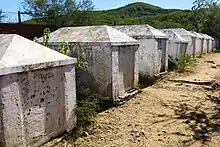
In 1862, silver and gold were discovered in the southern Baja California Sur mountains, leading miners from Mexico and the United States to rush to settle in El Triunfo in a gold rush.[4] Many of the miners had participated in the 1849 California gold rush.[4] In 1878, the mine was taken over by the British El Progreso Mining Company and became more successful. Once the largest city in Baja California Sur, it was home to more than 10,000 miners.[2] In its heyday the town was a cultural center, where Francisca Mendoza taught and performed.[5] El Triunfo was the first town in the region to install electricity and telephones.[6] Pianos and other instruments were brought to El Triunfo from around the world and a piano museum still exists.[7] When mines shut down in 1926, most of the townspeople left to look for work elsewhere.[2] The 2010 census reported a population of 327 inhabitants.[8] El Triunfo is one of the best preserved 19th and 20th century mining communities in North America and remains an important site for archaeological research.[9]
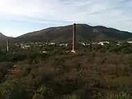
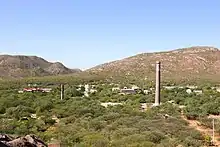
A notable feature of the town is the 47-meter-high[10] smokestack constructed in 1890 for El Progreso Mining Company. It is called "La Ramona", named after Saint Raymond, on whose feast day the project was completed on. The smokestack was once thought to be designed by Gustave Eiffel, though no conclusive evidence of his involvement in the project has been located.[6] After more than 100 years, the smokestack was cracked and damaged and collapse during an earthquake or hurricane was a concern.[6] In 2018, the nonprofits International Community Foundation (ICF) and the Corredor Histórico CAREM, A.C. collaborated to restore La Ramona for an estimated US$200,000.[6][11]
In recent years, to attract tourism, many of the original buildings have been restored and converted into restaurants, museums, boutiques and other locations.[2]
References
- ↑ 2020 La Paz Census
- 1 2 3 4 Kramer, Jennifer (2016-04-20). "The Renaissance of El Triunfo". Discover Baja Travel Club. Archived from the original on 2018-03-16. Retrieved 2019-03-24.
- ↑ "El Triunfo Los Cabos, Baja California Sur, Mexico". Los Cabos Guide. Archived from the original on 2018-05-09. Retrieved 2019-03-24.
- 1 2 "El Triunfo, Baja California Sur, Mexico: Carlos Fiesta's Baja Expo 2010". www.bajaexpo.com. Archived from the original on 2008-08-08. Retrieved 2019-03-24.
- ↑ "Escapes Magazine » Blog Archive » El Triunfo, a glorious quiet town". 2014-10-18. Archived from the original on 2014-10-18. Retrieved 2019-03-24.
- 1 2 3 4 Robinson, Lorin R. (2019-03-22). "Mining history will apparently not repeat Itself in Baja California Sur". Mexico News Daily. Retrieved 2019-03-24.
- ↑ "El Triunfo Piano Museum in Baja California Sur". 2012-03-29. Archived from the original on 2012-03-29. Retrieved 2019-03-24.
- ↑ "Catálogo de claves de entidades federativas, municipios y localidades". 2013-05-02. Archived from the original on 2013-05-02. Retrieved 2019-03-24.
- ↑ "Historical Archaeology of El Triunfo, 19th Century Mining Community of Baja California Sur, Mexico". gsa.confex.com. Archived from the original on 2012-02-19. Retrieved 2019-03-24.
- ↑ "Historic Landmark, "La Ramona" Smokestack, to be Restored in El Triunfo". Discover Baja Travel Club. 2016-11-08. Retrieved 2019-03-24.
- ↑ "La Ramona - CAREM Subfund". donate.icfdn.org. Retrieved 2019-03-24.