The electoral regions (circunscripciones electorales) of Mexico are geographic areas composed of various states used for the election of the 200 proportional representation legislators to the Chamber of Deputies.
Mexico is split into five separate regions. Each of the five regions sends 40 deputies, which are selected according to party lists in the regions.
The electoral regions are divided to ensure a roughly equal distribution of population among the regions and may be modified by the National Electoral Institute. The current distribution has been in use since September 30, 2005.
In contrast, the 32 senators-at-large elected to the Senate by the principle of proportional representation are drawn from party lists covering the entire country; the electoral regions therefore play no role in Senate elections.
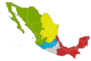 Mexico divided into the five electoral regions | ||||
| Color | Region | Seat | States | 2006 population[1] |
| First | Guadalajara, Jalisco | 21,136,816 | ||
| Second | Monterrey, Nuevo León | 21,417,106 | ||
| Third | Xalapa, Veracruz | 20,945,125 | ||
| Fourth | Mexico City | 20,173,001 | ||
| Fifth | Toluca, Estado de México | 21,172,323 | ||
See also
References
- ↑ Celia Palacios Mora; Erubiel Tirado Cervantes (2009). "Circunscripciones electorales plurinominales: configuración geográfica y equilibrio poblacional. 1977–2007". scielo.org.mx. Investigaciones geográficas No. 68.
External links
- Electoral Regions on the INE website