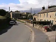
| Ellingstring | |
|---|---|
 Ellingstring village | |
.svg.png.webp) Ellingstring Location within North Yorkshire | |
| Population | 80 |
| OS grid reference | SE177832 |
| Unitary authority | |
| Ceremonial county | |
| Region | |
| Country | England |
| Sovereign state | United Kingdom |
| Post town | RIPON |
| Postcode district | HG4 |
| Dialling code | 01677 |
| Police | North Yorkshire |
| Fire | North Yorkshire |
| Ambulance | Yorkshire |
| UK Parliament | |
Ellingstring is a village and civil parish in Wensleydale in North Yorkshire, England, about 5 miles (8 km) south-east of Leyburn, and 3.5 miles (5.6 km) north of Masham.[1] It lies within the Harrogate district, but historically was in the wapentake of Hang East.[2] The population of the parish was estimated at 80 in 2012.[3]
The parish now shares a grouped parish council, known as Fearby, Healey and District Parish Council, with Colsterdale, Fearby, Healey and Ilton cum Pott.[4] It falls within the Skipton and Ripon constituency for the UK Parliament.[5] The name of the village was first recorded in 1198 as Elingstrengge, and derives from the Old English Ella and the Old Norse strengr, meaning watercourse.[6]
References
- ↑ Kelly's Directory of N & E Ridings of Yorkshire, 1893. London: Kellys Directories. 1893. p. 103. OCLC 1131686665.
- ↑ Kelly's Directory of N & E Ridings of Yorkshire, 1893. London: Kellys Directories. 1893. p. 5. OCLC 1131686665.
- ↑ "Population Estimates". North Yorkshire County Council. 2012. Archived from the original on 13 January 2012. Retrieved 5 May 2014.
- ↑ "The Parish". Fearby Healey and District Parish Council. Retrieved 29 April 2020.
- ↑ "Election Maps Ellingstring". www.ordnancesurvey.co.uk. Retrieved 8 February 2023.
- ↑ Smith, A. H. (1979) [1928]. The Place Names of the North Riding of Yorkshire. English Place Name Society. p. 231. OCLC 19714705.
External links
![]() Media related to Ellingstring at Wikimedia Commons
Media related to Ellingstring at Wikimedia Commons