Emerson | |||||||||||||
|---|---|---|---|---|---|---|---|---|---|---|---|---|---|
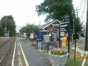
 The station at Emerson as seen on September 11, 2011 facing northbound towards Westwood. | |||||||||||||
| General information | |||||||||||||
| Location | 170 Kinderkamack Road (CR 503), Emerson, New Jersey 07630 | ||||||||||||
| Coordinates | 40°58′30″N 74°01′38″W / 40.9751°N 74.0273°W | ||||||||||||
| Owned by | New Jersey Transit | ||||||||||||
| Platforms | 1 side platform | ||||||||||||
| Tracks | 1 | ||||||||||||
| Connections | |||||||||||||
| Construction | |||||||||||||
| Parking | Yes (permit required) | ||||||||||||
| Bicycle facilities | Yes | ||||||||||||
| Other information | |||||||||||||
| Station code | 785 (Erie Railroad)[1] | ||||||||||||
| Fare zone | 8 | ||||||||||||
| History | |||||||||||||
| Opened | March 4, 1870[2] | ||||||||||||
| Passengers | |||||||||||||
| 2018 | 219 (average weekday)[3] | ||||||||||||
| Services | |||||||||||||
| |||||||||||||
| |||||||||||||
Emerson is an active commuter railroad station in the borough of Emerson, Bergen County, New Jersey. The station, serviced by trains of the Pascack Valley Line from Spring Valley in Rockland County, New York to Hoboken Terminal in Hudson County, New Jersey, is located at the intersection of Kinderkamack Road (County Route 503) and Linwood Avenue in Emerson. The next station to the north is Westwood while the next to the south is Oradell. The station has a single track and single low-level side platform along Kinderkamack Road, without handicap accessibility under the Americans with Disabilities Act of 1990.
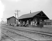
Rail service through Emerson began on March 4, 1870, with the opening of the Hackensack and New York Extension Railroad from Anderson Street station in Hackensack to Hillsdale station in the eponymous borough. At the time of opening, the station was known as Kinderkamack.[4][5] The area of Kinderkamack changed its name to Etna in 1877 when the post office changed. This changed in 1909 to Emerson.[6]
Station layout

The station has one track and one low-level side platform. Permit parking is operated by the Borough of Emerson. Three permit parking lots area available, with 38, 20 and 44 spots, respectively.
References
- ↑ "List of Station Names and Numbers". Jersey City, New Jersey: Erie Railroad. May 1, 1916. Retrieved November 23, 2010.
- ↑ Backus, Kathleen S. (March 21, 1957). "Removal of Historic Buildings Excites Interest in Borough". The Bergen Evening Record. Hackensack, New Jersey. p. 5. Retrieved July 30, 2020 – via Newspapers.com.

- ↑ Kiefer, Eric. "Here Are New Jersey Transit's Most, Least-Used Train Stations". patch.com. Retrieved August 28, 2022.
- ↑ "Railway Extension". The New York Times. March 6, 1870. p. 8. Retrieved August 30, 2022 – via Newspapers.com.

- ↑ Map of the Railroads of New Jersey and Parts of Adjoining States (Map). Cartography by J. A. Anderson. Philadelphia, Pennsylvania: J. L. Smith. 1873. Retrieved August 30, 2022.
- ↑ Grumet, Robert S. (2014). Beyond Manhattan: A Gazetteer of Delaware Indian History Reflected in Modern-Day Place Names (PDF) (Report). New York State Museum. pp. 43–44. Retrieved August 30, 2022.
External links
- Borough of Emerson
- Red and Tan Lines / Rockland Coaches site Archived December 2, 2016, at the Wayback Machine
- Station and Station House from Google Maps Street View