Erymanthos
Ερύμανθος | |
|---|---|
 Erymanthos municipality | |
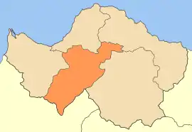
 Erymanthos Location within the region 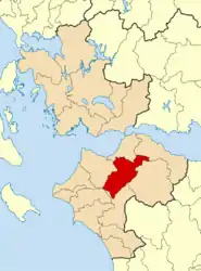 | |
| Coordinates: 38°6′N 21°47′E / 38.100°N 21.783°E | |
| Country | Greece |
| Geographic region | Peloponnese |
| Administrative region | Western Greece |
| Regional unit | Achaea |
| Area | |
| • Municipality | 582.1 km2 (224.8 sq mi) |
| Population (2011)[1] | |
| • Municipality | 8,877 |
| • Municipality density | 15/km2 (39/sq mi) |
| Time zone | UTC+2 (EET) |
| • Summer (DST) | UTC+3 (EEST) |
| Website | erymanthos.gov.gr |
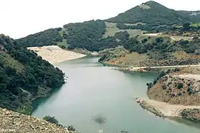
View of Ntaska Reservoir close to Erymantheia and Velimachi villages, Tritaia region, Achaia, Greece.
.jpg.webp)
Asteri Dam or Parapiros Dam in Erymanthos municipality. View of the lake. The temporary islet with Saint Theodores' chapel of Mitopolis village sinking. Mt. Erymanthos in the background.
Erymanthos (Greek: Ερύμανθος) is a municipality in the Achaea, Western Greece, Greece. The seat of the municipality is the town Chalandritsa.[2] The municipality has an area of 582.139 km2.[3] It was named after Mount Erymanthos.
Municipality
The municipality Erymanthos was formed at the 1/1/2011 local government reform by the merger of the following 4 former municipalities and communities, that became municipal units:[2]
References
- ↑ "Απογραφή Πληθυσμού - Κατοικιών 2011. ΜΟΝΙΜΟΣ Πληθυσμός" (in Greek). Hellenic Statistical Authority.
- 1 2 "ΦΕΚ A 87/2010, Kallikratis reform law text" (in Greek). Government Gazette.
- ↑ "Population & housing census 2001 (incl. area and average elevation)" (PDF) (in Greek). National Statistical Service of Greece. Archived from the original (PDF) on 2015-09-21.
External links
![]() Media related to Erymanthos at Wikimedia Commons
Media related to Erymanthos at Wikimedia Commons
| Regional unit of Achaea |  | |
|---|---|---|
| Regional unit of Aetolia-Acarnania | ||
| Regional unit of Elis | ||
| ||
This article is issued from Wikipedia. The text is licensed under Creative Commons - Attribution - Sharealike. Additional terms may apply for the media files.