| Espíritu Santo | |
|---|---|
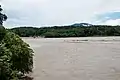
 San Matéo River and Espíritu Santo River (upper right) in Villa Tunari just before their confluence in the east of the town | |
| Location | |
| Country | Bolivia |
| Department | Cochabamba Department |
| Province | Chapare Province |
| Municipality | Villa Tunari Municipality |
| Physical characteristics | |
| Source | |
| • location | Serranía de Callejas |
| • coordinates | 17°11′56″S 65°41′11″W / 17.19889°S 65.68639°W |
| • elevation | 2,720 m (8,920 ft) |
| Mouth | |
• location | Villa Tunari |
• coordinates | 16°58′26″S 65°24′40″W / 16.97389°S 65.41111°W |
• elevation | 289 m (948 ft) |
| Length | 66 km (41 mi) |
| Basin features | |
| Tributaries | |
| • left | Lima Tambo, Juntas de Corani, Blanco |
| • right | Jordan Mayu, Arispe Mayu, Cristal Mayito, Cristal Mayu, Huayruruny, Avispas |
The Espíritu Santo River is a Bolivian river in the Cochabamba Department, Chapare Province, Villa Tunari Municipality.[1] It belongs to the Amazon River watershed. Espíritu Santo River originates in the Callejas mountains south west of Villa Tunari. It initially flows in a northeasterly direction, before turning to the east towards Villa Tunari. In the east of the town, it meets San Matéo River which comes from the south west. From the confluence the river is known as Chapare River.
See also
References
- ↑ Villa Tunari Municipality Archived 2016-03-03 at the Wayback Machine: population data and map showing Espíritu Santo River (unnamed) on its way from Mendoza to Villa Tunari
- lib.utexas.edu Detailed map of the area
- Rand McNally, The New International Atlas, 1993.
External links
 Media related to Espíritu Santo River at Wikimedia Commons
This article is issued from Wikipedia. The text is licensed under Creative Commons - Attribution - Sharealike. Additional terms may apply for the media files.