| Etton | |
|---|---|
.jpg.webp) St Mary's Church, Etton | |
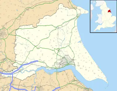
 Etton Location within the East Riding of Yorkshire | |
| Population | 277 (2011 census)[1] |
| OS grid reference | SE980435 |
| • London | 160 mi (260 km) S |
| Civil parish |
|
| Unitary authority | |
| Ceremonial county | |
| Region | |
| Country | England |
| Sovereign state | United Kingdom |
| Post town | BEVERLEY |
| Postcode district | HU17 |
| Dialling code | 01430 |
| Police | Humberside |
| Fire | Humberside |
| Ambulance | Yorkshire |
| UK Parliament | |
Etton is a village and civil parish in the East Riding of Yorkshire, England. It is situated approximately 4 miles (6 km) north-west of Beverley town centre and 2 miles (3.2 km) west of the village of Leconfield. 1 mile (1.6 km) to the south-east is Cherry Burton. To the west lie the hamlets of Kiplingcotes (3 miles (5 km) away due west) and Gardham (1.5 miles (2.4 km) to the south-west). South Dalton lies 1.5 miles to the north-west.
The village itself lies to the west of the B1248 road in its own shallow dale. The village's buildings are almost entirely situated either side of Main Street. Along this street lie both the village pub and the parish church of St Mary, which is a Grade II* listed building.[2]
The civil parish is formed by the village of Etton and part of the hamlet of Kiplingcotes. According to the 2011 UK Census, Etton parish had a population of 277,[1] a decrease on the 2001 UK Census figure of 285.[3]
Etton is significant as the 1584 birthplace of Rev John Lothropp, founder of Barnstable, Massachusetts. Several Lothropp family members have death or burial dates recorded as 6 January 1588, but as there is no record of a catastrophic event on that date, it is believed to be merely a recording date to catch up on vital statistics which had gone unreported for some length of time.
Thomas Carling, who emigrated from Etton to Canada in 1818, used 'a recipe from his native Yorkshire' to found the Carling Brewery in 1840.[4]
Etton is also home to the Holderness Hunt, whose kennels are located on the south-east of the village.[5]

In 1823 Etton was in the Wapentake of Harthill. The village had a population of 380, with occupations including nine farmers, two shopkeepers, a carpenter & wheelwright, a boot & shoe maker, a tailor, a corn miller, and the landlord of the Light Dragoon public house. There were two gentlemen, one gentlewoman, a Lady, a vicar, and a schoolmaster who was also the parish clerk. Once a week two carriers operated between the village and Beverley. The patron of the village Church of St Mary was the Archbishop of York.[6]
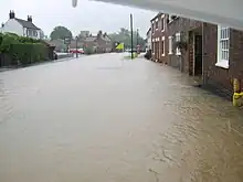
Etton has been known to suffer quite badly during floods, due to its position in a small valley, with the most recent flood on 25 June 2007.[7]
References
- 1 2 UK Census (2011). "Local Area Report – Etton Parish (1170211176)". Nomis. Office for National Statistics. Retrieved 17 February 2018.
- ↑ Historic England. "Church of St Mary (1103443)". National Heritage List for England. Retrieved 17 August 2013.
- ↑ UK Census (2001). "Local Area Report – Etton Parish (1543504222)". Nomis. Office for National Statistics. Retrieved 11 December 2018.
- ↑ Cooney, Michael (December 2002). Old Yorkshire. Vol. 26. Beverley: Northern Line Design. pp. 26–28.
- ↑ "Holderness Hunt invites public to witness sport for themselves". Hull Daily Mail. 23 October 2010. Retrieved 10 May 2016.
- ↑ Baines, Edward (1823). History, Directory and Gazetteer of the County of York. p. 203.
- ↑ "Estates and roads flooded across region". infoweb.newsbank.com. 25 June 2007. Retrieved 17 March 2023.
- Gazetteer — A–Z of Towns Villages and Hamlets. East Riding of Yorkshire Council. 2006. p. 5.
External links
 Media related to Etton at Wikimedia Commons
- Historic England. "St Mary's Church (1103443)". National Heritage List for England.
- Etton in the Domesday Book