Euclid | |
|---|---|
 Euclid  Euclid | |
| Coordinates: 47°58′19″N 96°38′20″W / 47.97194°N 96.63889°W | |
| Country | United States |
| State | Minnesota |
| County | Polk |
| Area | |
| • Total | 35.6 sq mi (92 km2) |
| • Land | 35.6 sq mi (92 km2) |
| • Water | 0 sq mi (0 km2) |
| Elevation | 896 ft (273 m) |
| Population | |
| • Total | 132 |
| • Density | 3.7/sq mi (1.4/km2) |
| Time zone | UTC-6 (Central (CST)) |
| • Summer (DST) | UTC-5 (CDT) |
| ZIP code | 56722 |
| Area code | 218 |
| GNIS feature ID | 643426[1] |
Euclid (/ˈjuːklɪd/ YOO-klid)[2] is an unincorporated community in Polk County, Minnesota, United States. It is situated on U.S. Route 75, 13.5 miles (21.7 km) north of Crookston. Euclid has a post office with ZIP code 56722.[3]
History
A post office called Euclid has been in operation since 1879.[4] The community was named after Euclid Avenue, a main boulevard of Cleveland, Ohio.[5]
Population
Euclid has a population of 132, of whom 54.5% are male and 45.5% female. The average age is estimated at 48.5. There are two main ethnicities, white and Hispanic, which are respectively 97% and 3% of the population. The average number of residents per household is estimated at 2.32, with an estimated 57 households in the area.[6]
| Census | Pop. | Note | %± |
|---|---|---|---|
| 1880 | 67 | — | |
| 1990 | 184 | — | |
| 2000 | 149 | −19.0% | |
| 2010 | 148 | −0.7% | |
| U.S. Decennial Census[7] | |||
References
- ↑ "US Board on Geographic Names". United States Geological Survey. October 25, 2007. Retrieved January 31, 2008.
- ↑ "Minnesota Pronunciation Guide". Associated Press. Archived from the original on July 22, 2011. Retrieved July 4, 2011.
- ↑ "ZIP Code Lookup". Archived from the original on August 5, 2012. Retrieved February 25, 2010.
- ↑ "Polk County". Jim Forte Postal History. Archived from the original on January 24, 2016. Retrieved July 31, 2015.
- ↑ Upham, Warren (1920). Minnesota Geographic Names: Their Origin and Historic Significance. Minnesota Historical Society. p. 424.
- ↑ "Euclid, Minnesota". Best Places. Retrieved April 21, 2020.
- ↑ United States Census Bureau. "Census of Population and Housing". Archived from the original on May 7, 2015. Retrieved December 15, 2017.
Municipalities and communities of Polk County, Minnesota, United States | ||
|---|---|---|
| Cities | 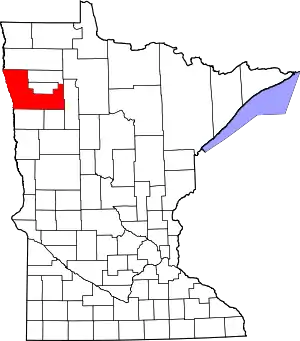 Map of Minnesota highlighting Polk County | |
| Townships |
| |
| Unincorporated communities | ||
| Indian reservation | ||
| Footnotes | ‡This populated place also has portions in an adjacent county or counties | |
This article is issued from Wikipedia. The text is licensed under Creative Commons - Attribution - Sharealike. Additional terms may apply for the media files.