 | |||||||||||||||||||||||||||||||||||||||||||||||||||||||||||||||||||||||||||||||||||||||||||
| General information | |||||||||||||||||||||||||||||||||||||||||||||||||||||||||||||||||||||||||||||||||||||||||||
| Location | 901 Davis Street Evanston, Illinois 60201 | ||||||||||||||||||||||||||||||||||||||||||||||||||||||||||||||||||||||||||||||||||||||||||
| Owned by | Union Pacific | ||||||||||||||||||||||||||||||||||||||||||||||||||||||||||||||||||||||||||||||||||||||||||
| Platforms | 2 side platforms | ||||||||||||||||||||||||||||||||||||||||||||||||||||||||||||||||||||||||||||||||||||||||||
| Tracks | 2 | ||||||||||||||||||||||||||||||||||||||||||||||||||||||||||||||||||||||||||||||||||||||||||
| Connections | Chicago "L": Davis (Purple Line) | ||||||||||||||||||||||||||||||||||||||||||||||||||||||||||||||||||||||||||||||||||||||||||
| Construction | |||||||||||||||||||||||||||||||||||||||||||||||||||||||||||||||||||||||||||||||||||||||||||
| Parking | Yes | ||||||||||||||||||||||||||||||||||||||||||||||||||||||||||||||||||||||||||||||||||||||||||
| Bicycle facilities | Yes | ||||||||||||||||||||||||||||||||||||||||||||||||||||||||||||||||||||||||||||||||||||||||||
| Accessible | Yes | ||||||||||||||||||||||||||||||||||||||||||||||||||||||||||||||||||||||||||||||||||||||||||
| Other information | |||||||||||||||||||||||||||||||||||||||||||||||||||||||||||||||||||||||||||||||||||||||||||
| Fare zone | C | ||||||||||||||||||||||||||||||||||||||||||||||||||||||||||||||||||||||||||||||||||||||||||
| History | |||||||||||||||||||||||||||||||||||||||||||||||||||||||||||||||||||||||||||||||||||||||||||
| Opened | 1910 | ||||||||||||||||||||||||||||||||||||||||||||||||||||||||||||||||||||||||||||||||||||||||||
| Rebuilt | 1978 | ||||||||||||||||||||||||||||||||||||||||||||||||||||||||||||||||||||||||||||||||||||||||||
| Passengers | |||||||||||||||||||||||||||||||||||||||||||||||||||||||||||||||||||||||||||||||||||||||||||
| 2018 | 1,876 (average weekday)[1] | ||||||||||||||||||||||||||||||||||||||||||||||||||||||||||||||||||||||||||||||||||||||||||
| Rank | 12 out of 236[1] | ||||||||||||||||||||||||||||||||||||||||||||||||||||||||||||||||||||||||||||||||||||||||||
| Services | |||||||||||||||||||||||||||||||||||||||||||||||||||||||||||||||||||||||||||||||||||||||||||
| |||||||||||||||||||||||||||||||||||||||||||||||||||||||||||||||||||||||||||||||||||||||||||
| |||||||||||||||||||||||||||||||||||||||||||||||||||||||||||||||||||||||||||||||||||||||||||
| |||||||||||||||||||||||||||||||||||||||||||||||||||||||||||||||||||||||||||||||||||||||||||
| Location | |||||||||||||||||||||||||||||||||||||||||||||||||||||||||||||||||||||||||||||||||||||||||||
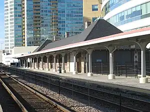
Evanston Davis Street is a commuter railroad station in downtown Evanston, Illinois. It is served by Metra's Union Pacific North Line with trains going south to Ogilvie Transportation Center in Chicago and as far north as Kenosha, Wisconsin. In Metra's zone-based fare system, Davis Street is in zone C. As of 2018, Evanston Davis Street is the 12th busiest of Metra's 236 non-downtown stations, with an average of 1,876 weekday boardings.[1] The station is next to the Davis station of the Chicago Transit Authority's Purple Line, where CTA and Pace buses terminate. Between the two stations is 909 Davis Street, a six-story building with a kiss-and-ride loop for car drop-off.
Davis Street station, at Davis Street and Maple Avenue, has two elevated platforms. Northbound trains stop at the west platform and southbound trains stop at the east platform. The ticket agent's office is on the east platform. At ground level, there is a restaurant called Chef's Station.[2] Just to the east of the Davis CTA station is the 12-story Sherman Avenue Garage.
As of April 25, 2022, Evanston Davis Street is served by all 70 trains (35 in each direction) on weekdays, by 24 trains (12 in each direction) on Saturdays, and by all 18 trains (nine in each direction) on Sundays and holidays. During the summer concert season, the extra weekend train to Ravinia Park also stops here.
This is the closest Metra station to most of the buildings on Northwestern University's Evanston campus, with the exception of Ryan Field, which is closer to the Evanston Central Street station.
History
When the Chicago & Milwaukee railroad, the predecessor of the Chicago and North Western Railway was built, there was only a single track.[3] The stations were placed on the North side of tracks on the other C&NW West line, the original Chicago and Galena Union line.[4] The station buildings were built on the side for inbound Chicago passengers.
The Davis Street station was the only stop in Evanston for intercity Chicago and North Western Railway trains, such as the Twin Cities 400.[5] The Union Pacific bought the assets of the C&NW.
Transportation
The Davis Street Metra station is only steps west of the CTA station and, together with that station, forms a transportation center allowing easy transfer from one station to the other, there is also a pedestrian walkway.
Rail
Bus
- 93 California/Dodge (Monday–Saturday only)
- 201 Central/Ridge (Monday–Saturday only)
- 206 Evanston Circulator (school days only)
- 208 Golf Road
- 213 Green Bay Road
- 250 Dempster Street
- Pulse Dempster Line
References
- 1 2 3 "Commuter Rail System Station Boarding/Alighting Count: Summary Results Fall 2018" (PDF). Metra. April 2019. Archived from the original (PDF) on 26 May 2019.
- ↑ "Chef's Station - Evanston, IL 60201 / Metromix Chicago". Archived from the original on January 1, 2008. Retrieved 2008-12-17.
- ↑ Hermes, Tom - Why Does Our Train Run on the Wrong Track? Winnetka Historical Society Gazette, Fall 1996
- ↑ Ask Geoffrey: 10/9 WTTW News, October 9, 2013
- ↑ Chicago & North Western Railway Route of the "400" The Streamliners and the Challengers [Time Table]. Rand McNally, January 15, 1939. Chicago, IL
External links
![]() Media related to Evanston Davis Street (Metra) at Wikimedia Commons
Media related to Evanston Davis Street (Metra) at Wikimedia Commons