Finzel, Maryland | |
|---|---|
 Finzel  Finzel | |
| Coordinates: 39°42′52″N 78°56′43″W / 39.71444°N 78.94528°W | |
| Country | United States |
| State | Maryland |
| County | Garrett |
| Area | |
| • Total | 3.94 sq mi (10.20 km2) |
| • Land | 3.94 sq mi (10.20 km2) |
| • Water | 0.00 sq mi (0.00 km2) |
| Elevation | 2,543 ft (775 m) |
| Population (2020) | |
| • Total | 495 |
| • Density | 125.67/sq mi (48.52/km2) |
| Time zone | UTC-5 (Eastern (EST)) |
| • Summer (DST) | UTC-4 (EDT) |
| Area code(s) | 301, 240 |
| GNIS feature ID | 590209[2] |
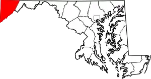
Finzel is a census-designated place (CDP) in Garrett County, Maryland, United States. Finzel is located on Maryland Route 546 near the Pennsylvania border. As of the 2010 census, its population was 547.[3]
Demographics
| Census | Pop. | Note | %± |
|---|---|---|---|
| 2020 | 495 | — | |
| U.S. Decennial Census[4] | |||
References
- ↑ "2020 U.S. Gazetteer Files". United States Census Bureau. Retrieved April 26, 2022.
- ↑ "Finzel". Geographic Names Information System. United States Geological Survey, United States Department of the Interior.
- ↑ "U.S. Census website". United States Census Bureau. Retrieved May 14, 2011.
- ↑ "Census of Population and Housing". Census.gov. Retrieved June 4, 2016.
Wikimedia Commons has media related to Finzel, Maryland.
This article is issued from Wikipedia. The text is licensed under Creative Commons - Attribution - Sharealike. Additional terms may apply for the media files.
