| Flinders Lofty Block South Australia | |||||||||||||||
|---|---|---|---|---|---|---|---|---|---|---|---|---|---|---|---|
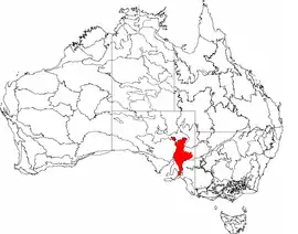
 The interim Australian bioregions, with the Flinders Lofty Block in red | |||||||||||||||
| Area | 66,157.65 km2 (25,543.6 sq mi) | ||||||||||||||
| |||||||||||||||
Flinders Lofty Block is an interim Australian bioregion located in South Australia.[1] It has an area of 6,615,765 hectares (16,347,910 acres),[2] which includes the Mount Lofty Ranges and Flinders Ranges.
Subregions
Flinders Lofty Block consists of six subregions
- Mount Lofty Ranges (FLB01) – 300,580 hectares (742,700 acres)
- Broughton (FLB02) – 1,032,918 hectares (2,552,400 acres)
- Olary Spur (FLB03) – 1,745,479 hectares (4,313,170 acres)
- Southern Flinders (FLB04) – 728,317 hectares (1,799,710 acres)
- Northern Flinders (FLB05) – 1,846,804 hectares (4,563,550 acres)
- Central Flinders (FLB06) – 961,667 hectares (2,376,330 acres)
The Mount Lofty Ranges and Broughton subregions are part of the Mount Lofty woodlands ecoregion.[3] The other subregions are part of the Tirari–Sturt stony desert ecoregion.
References
- ↑ Environment Australia. "Revision of the Interim Biogeographic Regionalisation for Australia (IBRA) and Development of Version 5.1 – Summary Report" (PDF). Department of the Environment and Water Resources, Australian Government. Retrieved 3 May 2022.
{{cite journal}}: Cite journal requires|journal=(help) - ↑ "Interim Biogeographic Regionalisation for Australia (IBRA7) regions and codes". Department of Sustainability, Environment, Water, Population and Communities. Commonwealth of Australia. 2012. Retrieved 3 May 2022.
- ↑ "Mount Lofty woodlands". Terrestrial Ecoregions. World Wildlife Fund.
This article is issued from Wikipedia. The text is licensed under Creative Commons - Attribution - Sharealike. Additional terms may apply for the media files.