Fontcouverte | |
|---|---|
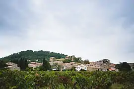 A general view of Fontcouverte | |
.svg.png.webp) Coat of arms | |
Location of Fontcouverte | |
 Fontcouverte  Fontcouverte | |
| Coordinates: 43°10′08″N 2°41′22″E / 43.1689°N 2.6894°E | |
| Country | France |
| Region | Occitania |
| Department | Aude |
| Arrondissement | Narbonne |
| Canton | Les Corbières |
| Intercommunality | Région Lézignanaise, Corbières et Minervois |
| Government | |
| • Mayor (2020–2026) | Jacques Conties[1] |
| Area 1 | 9.97 km2 (3.85 sq mi) |
| Population | 567 |
| • Density | 57/km2 (150/sq mi) |
| Time zone | UTC+01:00 (CET) |
| • Summer (DST) | UTC+02:00 (CEST) |
| INSEE/Postal code | 11148 /11700 |
| Elevation | 62–189 m (203–620 ft) (avg. 65 m or 213 ft) |
| 1 French Land Register data, which excludes lakes, ponds, glaciers > 1 km2 (0.386 sq mi or 247 acres) and river estuaries. | |
Fontcouverte (French pronunciation: [fɔ̃kuvɛʁt] ⓘ; Occitan: Fontcobèrta) is a commune in the Aude department in southern France.
Population
| Year | Pop. | ±% |
|---|---|---|
| 1962 | 388 | — |
| 1968 | 397 | +2.3% |
| 1975 | 336 | −15.4% |
| 1982 | 328 | −2.4% |
| 1990 | 333 | +1.5% |
| 1999 | 424 | +27.3% |
| 2008 | 563 | +32.8% |
Sights
- Monument Saint Régis
- Fountain on the Place de la Révolution, built in the late 19th century
- A column 4.40 m high with a statue of a woman symbolizing agriculture
- Montagne d'Alaric
See also
References
- ↑ "Répertoire national des élus: les maires" (in French). data.gouv.fr, Plateforme ouverte des données publiques françaises. 13 September 2022.
- ↑ "Populations légales 2021". The National Institute of Statistics and Economic Studies. 28 December 2023.
Wikimedia Commons has media related to Fontcouverte, Aude.
This article is issued from Wikipedia. The text is licensed under Creative Commons - Attribution - Sharealike. Additional terms may apply for the media files.