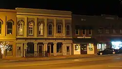
Franklin Downtown Commercial District | |
 | |
  | |
| Location | Roughly Main and College Sts. between Washington and Madison Sts. (original); also 200 S. Main and 207 S. College Sts. (increase) Franklin, Kentucky |
|---|---|
| Coordinates | 36°43′22″N 86°34′43″W / 36.72278°N 86.57861°W |
| Area | 15 acres (6.1 ha) (original) 1 acre (0.40 ha) (increase) |
| Built | 1822 |
| Architectural style | Mixed (more Than 2 Styles From Different Periods) |
| NRHP reference No. | 83002873[1] (original) 83002874 (increase) |
| Significant dates | |
| Added to NRHP | February 17, 1983 |
| Boundary increase | August 18, 1983 |
The Franklin Downtown Commercial District, in Franklin, Kentucky, is a historic district which was listed on the National Register of Historic Places in 1983. The listing was expanded later in the same year.[1]
The original listing included 50 contributing buildings, including the Simpson County Courthouse which was already separately listed on the National Register.[2]
The increase added four contributing buildings:
- the Dr. J.C. Douglas House (c.1850-1875), an Italianate I-house built with common bond brick
- the Southern Kentucky Sanatorium (c.1900) and Annex (1912), post-Victorian structures, and
- the Grainger Apartments (1927), a Georgian Revival structure.[3]
References
- 1 2 "National Register Information System". National Register of Historic Places. National Park Service. November 2, 2013.
- ↑ Richard M. Pfefferkorn (September 30, 1982). "National Register of Historic Places Inventory/Nomination: Franklin Downtown Commercial District". National Park Service. Retrieved May 2, 2018. With accompanying 39 photos from 1982
- ↑ Kevin A. Hunter (May 20, 1983). "National Register of Historic Places Inventory/Nomination: Franklin Downtown Commercial District (Boundary Increase)". National Park Service. Retrieved May 2, 2018. With accompanying 11 photos from 1983
This article is issued from Wikipedia. The text is licensed under Creative Commons - Attribution - Sharealike. Additional terms may apply for the media files.