Franklin Township | |
|---|---|
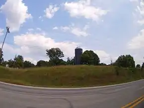 Silo on a hill from U.S. 231 in Franklin Township | |
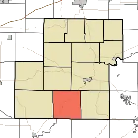 Location in Owen County | |
| Coordinates: 39°12′38″N 86°51′01″W / 39.21056°N 86.85028°W | |
| Country | |
| State | |
| County | Owen |
| Government | |
| • Type | Indiana township |
| Area | |
| • Total | 35.09 sq mi (90.9 km2) |
| • Land | 35.09 sq mi (90.9 km2) |
| • Water | 0 sq mi (0 km2) 0% |
| Elevation | 633 ft (193 m) |
| Population (2010) | |
| • Total | 1,269 |
| • Density | 36.2/sq mi (14.0/km2) |
| ZIP codes | 47431, 47460, 47471 |
| GNIS feature ID | 453310 |
Franklin Township is one of thirteen townships in Owen County, Indiana, United States. As of the 2010 census, its population was 1,269 and it contained 551 housing units.[1]
History
Franklin Township was founded in 1819.[2]
Geography
According to the 2010 census, the township has a total area of 35.09 square miles (90.9 km2), all land.[1]
Unincorporated towns
- Adel at 39°11′31″N 86°47′45″W / 39.191989°N 86.795839°W
- Farmers at 39°10′31″N 86°53′30″W / 39.175322°N 86.891674°W
- Freedom at 39°12′25″N 86°52′09″W / 39.206989°N 86.869174°W
- New Hope at 39°10′59″N 86°49′40″W / 39.183100°N 86.827784°W
- Pottersville at 39°12′26″N 86°48′51″W / 39.207267°N 86.814173°W
- Vilas at 39°10′12″N 86°50′24″W / 39.170045°N 86.840006°W
(This list is based on USGS data and may include former settlements.)
Cemeteries
The township contains these eighteen cemeteries: Adel, Burkett, Burton, Camden, Defore, Franklin, Hicks, Leach, Light, McIndoo, McKee, Neeley, Oliphant, Pryor, Scott, Waker, White and White.
Major highways
School districts
- Spencer-Owen Community Schools
Political districts
- State House District 46
- State Senate District 39
References
- "Franklin Township, Owen County, Indiana". Geographic Names Information System. United States Geological Survey, United States Department of the Interior. Retrieved October 23, 2009.
- United States Census Bureau 2009 TIGER/Line Shapefiles at the Library of Congress Web Archives (archived 2010-05-05)
- IndianaMap
- 1 2 "Population, Housing Units, Area, and Density: 2010 - County -- County Subdivision and Place -- 2010 Census Summary File 1". United States Census. Archived from the original on February 12, 2020. Retrieved May 10, 2013.
- ↑ Blanchard, Charles (1884). Counties of Clay and Owen, Indiana: Historical and Biographical. F.A. Battey & Company. pp. 751.
External links
- Indiana Township Association
- United Township Association of Indiana
- City-Data.com page for Franklin Township
Places adjacent to Franklin Township, Owen County, Indiana | |
|---|---|
Municipalities and communities of Owen County, Indiana, United States | ||
|---|---|---|
| Towns | Map of Indiana highlighting Owen County | |
| Townships | ||
| CDPs | ||
| Other communities | ||
| Ghost town | ||
| Footnotes | ‡This populated place also has portions in an adjacent county or counties | |
This article is issued from Wikipedia. The text is licensed under Creative Commons - Attribution - Sharealike. Additional terms may apply for the media files.