JE 03 Futajima Station 二島駅 | |||||||||||
|---|---|---|---|---|---|---|---|---|---|---|---|
 | |||||||||||
| General information | |||||||||||
| Location | 1-1-1 Futajima, Wakamatsu Ward, Kitakyushu City, Fukuoka Prefecture Japan | ||||||||||
| Operated by | |||||||||||
| Line(s) | JE Wakamatsu Line (Chikuhō Main Line) | ||||||||||
| Platforms | 2 side platforms | ||||||||||
| Tracks | 2 | ||||||||||
| Connections | |||||||||||
| Construction | |||||||||||
| Structure type | At grade | ||||||||||
| Other information | |||||||||||
| Station code | JE03 | ||||||||||
| History | |||||||||||
| Opened | 5 August 1899 | ||||||||||
| Passengers | |||||||||||
| FY2021 | 1,204 daily (boarding only) | ||||||||||
| Rank | 122nd (among JR Kyushu stations) | ||||||||||
| Services | |||||||||||
| |||||||||||
| Location | |||||||||||
 JE 03 Futajima Station Location within Fukuoka Prefecture  JE 03 Futajima Station JE 03 Futajima Station (Kyushu)  JE 03 Futajima Station JE 03 Futajima Station (Japan) | |||||||||||
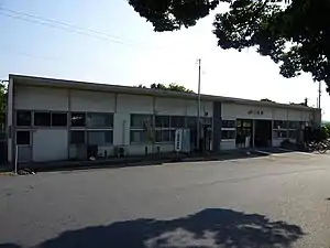
Futajima Station (二島駅, Futajima-eki) is a railway station on the Kyūshū Railway Company (JR Kyūshū) Chikuhō Main Line (also known as the Wakamatsu Line) in Wakamatsu-ku, Kitakyushu, Fukuoka Prefecture, Japan.
Station layout
| 1 | ■ Wakamatsu Line (Chikuhō Main Line) | for Wakamatsu |
| 2 | ■ Wakamatsu Line (Chikuhō Main Line) | for Orio, Nakama, and Nōgata |
History
The station opened in 1899.
History
The privately run Chikuho Kogyo Railway had opened a line from Wakamatsu to Nōgata on 30 August 1891. By 1895, the line had been extended south to Iezuka. On 1 October 1897, the Chikuho Kogyo Railway, now renamed the Chikuho Railway, merged with the Kyushu Railway. Kyushu Railway opened Futajima on 5 September 1899 as an additional station along this stretch of track. After the Kyushu Railway was nationalized on 1 July 1907, Japanese Government Railways (JGR) took over control of the station. On 12 October 1909, the station became part of the Chikuho Main Line. With the privatization of Japanese National Railways (JNR), the successor of JGR, on 1 April 1987, control of the station passed to JR Kyushu.[1][2]
On 4 March 2017, Futajima, along with several other stations on the line, became a "Smart Support Station". Under this scheme, although the station is unstaffed, passengers using the automatic ticket vending machines or ticket gates can receive assistance via intercom from staff at a central support centre which is located at Nakama.[3]
Passenger statistics
In fiscal 2016, the station was used by an average of 1,412 passengers daily (boarding passengers only), and it ranked 122nd among the busiest stations of JR Kyushu.[4]
Surrounding area
It is the westernmost train station among four stations in Wakamatsu-ku, all of those are on the Chikuho Main Line. National Route 199 runs immediately north of the station. Other points of interest include:
- Honjō Athletic Stadium - 1.5 km west
- ÆON Wakamatsu Shopping Center - 0.5 km northwest
- Kōryō High School - 0.4 km northwest
- Fukuoka prefectural Wakamatsu Commercial High School - 1.3 km north-northwest
- Green Park Kitakyushu, Hibiki Animal World, Tonda reservoir - 4 km north-northwest
- Waita beach - 6 km north-northwest
The nearest bus stops for Kitakyushu City Buses are located near the station along Route 199.
There is also a taxi stand outside the station's north exit.
References
- ↑ Ishino, Tetsu; et al., eds. (1998). 停車場変遷大事典 国鉄・JR編 [Station Transition Directory – JNR/JR] (in Japanese). Vol. I. Tokyo: JTB Corporation. p. 233. ISBN 4-533-02980-9.
- ↑ Ishino, Tetsu; et al., eds. (1998). 停車場変遷大事典 国鉄・JR編 [Station Transition Directory – JNR/JR] (in Japanese). Vol. II. Tokyo: JTB Corporation. pp. 784–5. ISBN 4-533-02980-9.
- ↑ "筑豊本線の一部が「Smart Support Station」に変わります" [Part of the Chikuho Line to become "Smart Support Stations"] (PDF). JR Kyushu. 3 February 2017. Retrieved 2 March 2018.
- ↑ "駅別乗車人員上位300駅(平成28年度)" [Passengers embarking by station - Top 300 stations (Fiscal 2016)] (PDF). JR Kyushu. 31 July 2017. Archived from the original (PDF) on 1 August 2017. Retrieved 25 February 2018.
External links
- Futajima Station (in Japanese)
33°53′23″N 130°44′54″E / 33.889687°N 130.748413°E