Gölenkamp | |
|---|---|
 Coat of arms | |
Location of Gölenkamp within Grafschaft Bentheim district 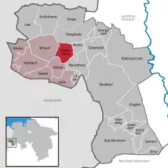 | |
 Gölenkamp 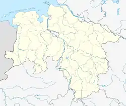 Gölenkamp | |
| Coordinates: 52°31′00″N 06°55′00″E / 52.51667°N 6.91667°E | |
| Country | Germany |
| State | Lower Saxony |
| District | Grafschaft Bentheim |
| Municipal assoc. | Uelsen |
| Subdivisions | 3 centres |
| Government | |
| • Mayor | Fritz-Geert Everink |
| Area | |
| • Total | 20.95 km2 (8.09 sq mi) |
| Elevation | 19 m (62 ft) |
| Population (2021-12-31)[1] | |
| • Total | 577 |
| • Density | 28/km2 (71/sq mi) |
| Time zone | UTC+01:00 (CET) |
| • Summer (DST) | UTC+02:00 (CEST) |
| Postal codes | 49843 |
| Dialling codes | 0 59 41 |
| Vehicle registration | NOH |
| Website | www.uelsen.de |
Gölenkamp is a community in the district of Grafschaft Bentheim in Lower Saxony.
Geography
Location
Gölenkamp lies northwest of Nordhorn. It belongs to the Joint Community (Samtgemeinde) of Uelsen, whose administrative seat is in the town of the same name.
Constituent communities
The community’s three centres are Gölenkamp, Haftenkamp and Hardinghausen.
Politics
Mayor
Jan Benierman was elected honorary mayor in 2006.
Culture and sightseeing
Buildings
Spöllberg, a barrow from the Bronze Age, is located in Gölenkamp.
References
External links
This article is issued from Wikipedia. The text is licensed under Creative Commons - Attribution - Sharealike. Additional terms may apply for the media files.