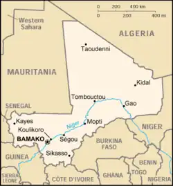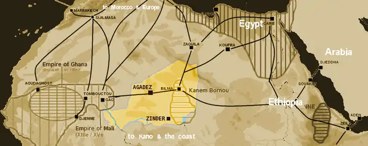
Located on the Niger Bend in present-day Mali, Gao was the political center of a trading state known to Arab chroniclers as Gawgaw, from the seventh to the thirteenth century CE.[1] Historical accounts indicate that Gawgaw included a trading town called Sarneh, and across the river, a royal town with a palace and mosque, and king whose treasure was salt.[2] Gao-Saney is a large settlement mound seven km distant from the royal town of Gao, and is thought to be the site of the ancient trading center. The site has produced extensive archaeological evidence from its first millennium occupation, with proposed chronology between 700 and 1100 CE.[3] Another archaeology site, Gao Ancien, roughly corresponds with descriptions of the royal town, but further research is needed.
Gao Empire | |||||||
|---|---|---|---|---|---|---|---|
| c. 7th century–1430 | |||||||
| Capital | Gao[4] | ||||||
| Common languages | Songhai | ||||||
| Religion | Islam, African traditional religion | ||||||
| Government | Empire | ||||||
| Historical era | Postclassical Era | ||||||
• Established | c. 7th century | ||||||
• Disestablished | 1430 | ||||||
| |||||||
| Today part of | Mali | ||||||
Gao is situated within the Sahelian climatic zone, which is defined as the area of transition between the Sahara and Sudanian savanna. This area is characterized by high temperatures and fluctuating rainfall.[5] In modern day, the Gao region is too dry to sustain year-round habitation without digging deep wells, leading to speculation about different climate conditions, perhaps with increased rainfall, at the time of Gao's first millennium occupation.
Gao-Saney excavations demonstrate involvement of the site in glass and copper trade networks during the eighth to tenth centuries on a scale only exceeded by Igbo Ukwu among known sub-Saharan sites.[3]
Subsistence Economy & Production
Livestock
Gao Saney had a mixed millet, caprine, and cattle based subsitence economy. Goats and sheep were very populous, significantly outnumbering cattle, while camels appear only sometimes in the faunal assemblage, and were likely consumed and used for transport.[3]
Copper
809 copper-based artifacts have been found, with almost half of them shaped as copper crescents. Given their consistent shape, it has been hypothesized that the copper crescents were used as currency, however, most of the copper artifacts found have been fragments, making it difficult to test this hypothesis.[3]
.jpg.webp)
Glass
 processing was among the earliest activities that took place. Thousands of glass beads have been found in and around Gao, dating from the eighth to the fourteenth century CE.[6] Their shapes include cylinder, oblate, sphere, tube, ellipsoid, bicone, and disc, and colors range from red to blue to yellow. Analyzing the composition of the beads can indicate their origins; several compositional groupings have been recognized, included plant-ash soda-lime-silica glass, mineral soda-lime-silica glass, high-lime high-alumina glass, mineral soda-high alumina glass, plant ash soda-high alumina glass and a high lead composition glass. The dating of these different composites indicates that the source of the glass used to make the beads changed sometime during the end of the tenth century. Earlier glasses were probably produced in Iraq and Baghdad, and later glasses were produced in Egypt.[6]
Trade
Gao Saney participated in regional and long-distance trade, indicated by extensive glass compositions sourced in the Middle East, and non-local items such as carnelian, flint, and granite grinding stones.[7]
Understanding how trade networks developed over time will require further research. However, at the moment, data indicates that the region surrounding Gao was involved in trade networks that moved imported glass and copper from distant sources, beginning by 400 CE. Excavations at Gao Saney show its involvement in the trade networks in the eighth through tenth centuries on a scale only exceeded by Igbo Ukwu among known sub-Saharan sites.[3]

Additionally, salt was noted as a large part of the king's treasure at Gao. Supposedly, Gao controlled an underground salt mine, however, salt is archaeologically invisible.
The number of imports exploded with the penetration of Islam into West Africa. During the late eight century CE, Ibadimerchants established the earliest recorded contact with Gao, corresponding to the same time that dry-stone architecture, wheat, and glass appear in the area. According to McIntosh, "throughout this period, the spread of Islam, literacy, a common language, and Sharia law contributed to increased efficiency, trust, financing, and security within more expansive trade networks."[8]
Material Culture

The earliest material culture at Gao-Saney, including its pottery, suggest Songhai-Berber presence rather than Arabic. Historical evidence indicates that the king of Gao converted to Islam during the 10th century.[9] Archaeologically, the cemetery stelae are the main evidence for Islam at Gao.
Pottery
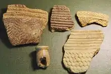
An excavation of 5700 rim and body sherds showed Gao Saney's ceramic assemblage to be largely homogeneous throughout all the deposits.[3] Most of the vessels were organic-tempered jars with long funnel-like rims decorated with broad channels, typically painted with a combination of white, black, and red paint. There were also small simple-rim bowls decorated with impressed comb in linear or geometric patterns. The presence of very similar pottery assemblages near places like Timbuktu, Gourma Rharous, and Bentia indicate river-based cultural interaction along the Middle Niger.[3]
Stelae

Gao-Saney became well known among African historians because French administrators discovered here in a cave covered with sand in 1939 several finely carved marble stelae produced in Almeria in Southern Spain.[10] Their inscriptions bear witness of three kings of a Muslim dynasty bearing as loan names the names of Muhammad and his two successors. From the dates of their deaths it appears that these kings of Gao ruled at the end of the eleventh and the beginning of the twelfth centuries CE, and represent a transition in leadership.[11]
Elites and Leadership
According to recent research, the Zaghe kings commemorated by the stelae are identical with the kings of the Za dynasty whose names were identified by the chroniclers of Timbuktu in the Ta'rikh al-Sudan and in the Ta'rikh al-Fattashas the founders of Gao. Their Islamic loan name is in one case complemented by their African name. It is on the basis of their common ancestral name Zaghe corresponding to Za and the third royal name Yama b. Kama provided in addition to 'Umar b. al-Khattab that the identity between the Zaghe and the Za could be established.
| Kings of Gao-Saney (1100 to 1120 CE)[12] | ||||||||||||
| Stelae of Gao-Saney | Ta'rīkh al-fattāsh | Ta'rīkh al-sūdān | ||||||||||
|---|---|---|---|---|---|---|---|---|---|---|---|---|
| Kings of the Zāghē | Date of death | Kings of the Zā | Kings of the Zā | |||||||||
| Abū 'Abd Allāh Muhammad st. 1100 | st. 1100 | (16) Kotso-Dare | (16) Kusoy-Dare | |||||||||
| Abū Bakr b. Quhāfa st. 1110 | st. 1110 | (17) Hizka-Zunku-Dam | (17) Hunabonua-Kodam | |||||||||
| Umar b. al-Khattāb = | ||||||||||||
It appears from this table that Yama b. Kima (or 'Umar b. al-Khattab), the third king of the stelae of Gao-Saney, is identical with the 18th ruler of the list of Za kings. His name is given in the Ta'rikh al-Fattash (1665) as Yama-Kitsi and in the Ta'rikh al-Sudan (1655) as Biyu-Ki-Kima. On account of this identification the dynastic history of the Gao Empirecan now to be established on a solid documentary basis.[13]
See also
References
- ↑ McIntosh, S.K. 2016. Gao Empire. In: MacKenzie, J. (ed.), The Encyclopedia of Empire. Wiley online.
- ↑ Mcintosh, Susan Keech (2020-02-29), "Long-Distance Exchange and Urban Trajectories in the First Millennium AD", Urbanisation and State Formation in the Ancient Sahara and Beyond, Cambridge University Press, pp. 521–563, retrieved 2023-04-22
- 1 2 3 4 5 6 7 Cissé, Mamadou; McIntosh, Susan Keech; Dussubieux, Laure; Fenn, Thomas; Gallagher, Daphne; Smith, Abigail Chipps (2013). "Excavations at Gao Saney: New Evidence for Settlement Growth, Trade, and Interaction on the Niger Bend in the First Millennium CE". Journal of African Archaeology. 11 (1): 9–37. ISSN 1612-1651.
- ↑ Bethwell A. Ogot, Africa from the Sixteenth to the Eighteenth Century, (UNESCO Publishing, 2000), 303.
- ↑ dlewis (2021-04-16). "The Sahel Faces 3 Issues: Climate, Conflict & Overpopulation". Vision of Humanity. Retrieved 2023-04-22.
- 1 2 McIntosh, S. K., Wood, M., Dussubieux, L., Robertshaw, P., Insoll, T., & Cissé, M. (2020). Glass Beads from Medieval Gao (Mali): New Analytical Data on Chronology, Sources, and Trade, Journal of African Archaeology, 18(2), 139-161. doi:10.1163/21915784-20200009
- ↑ MacDonald, Kevin (2013-07-04). "Complex Societies, Urbanism, and Trade in the Western Sahel". Oxford Handbooks Online. doi:10.1093/oxfordhb/9780199569885.013.0057.
- ↑ McIntosh, Susan (1996). "West African Savanna Kingdoms: The Sahara, Caravan Trade, and Islam". Oxford Companion to Archaeology (2 ed.) – via Oxford University Press.
- ↑ McIntosh, Susan Keech (2023), "West Africa: Villages, Cities, and Early States", Reference Module in Social Sciences, Elsevier, ISBN 978-0-443-15785-1, retrieved 2023-04-22
- ↑ Leube, G. (2016). Sacred Topography: A Spatial Approach to the stelae of Gao-Saney. Islamic Africa, 7(1), 44–59. JSTOR 90017587
- ↑ Sauvaget, "Épitaphes", 418.
- ↑ Lange, Kingdoms, 503
- ↑ Lange, Kingdoms, 498-509; Moraes Farias ignoriert die Synchronismen, Inscriptions, 3-8;