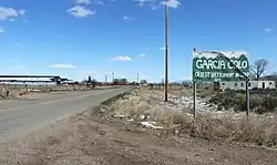
Garcia, Colorado | |
|---|---|
 Entering Garcia from New Mexico. | |
| Coordinates: 37°00′15″N 105°32′14″W / 37.00417°N 105.53722°W | |
| Country | |
| State | |
| Counties | Costilla[1] |
| Elevation | 7,730 ft (2,360 m) |
| Time zone | UTC-7 (MST) |
| • Summer (DST) | UTC-6 (MDT) |
| ZIP Code[2] | 81152 |
| Area code | 719 |
| GNIS feature | 204793[1] |
Garcia is an unincorporated community located in Costilla County, Colorado, United States. The San Luis post office (Zip Code 81152) serves Garcia postal addresses.[2]
History
Original settled in 1849 as La Plaza de los Manzanares,[3] Garcia rivals San Luis as the oldest continuously occupied settlement in Colorado.[4] A post office called Garcia was established in 1915.[5] The community was named for the local Garcia family.[6]
References
- 1 2 3 U.S. Geological Survey Geographic Names Information System: Garcia, Colorado
- 1 2 "Look Up a ZIP Code". United States Postal Service. Retrieved February 19, 2021.
- ↑ Tushar, Olibama López (2007). The people of El Valle : a history of the Spanish settlers in the San Luis Valley (4th ed.). Pueblo, Colo.: El Escritorio. ISBN 0-9628974-6-9. OCLC 310960699.
- ↑ Rosso, Mike (November 1, 2010). "Lines in the sand". Colorado Central Magazine. Retrieved February 28, 2023.
- ↑ "Post offices". Jim Forte Postal History. Archived from the original on March 6, 2016. Retrieved June 25, 2016.
- ↑ Dawson, John Frank. Place names in Colorado: why 700 communities were so named, 150 of Spanish or Indian origin. Denver, CO: The J. Frank Dawson Publishing Co. p. 23.
This article is issued from Wikipedia. The text is licensed under Creative Commons - Attribution - Sharealike. Additional terms may apply for the media files.
