Image of Square of map project, showing red dots where photos have been taken
Geograph Channel Islands is a web-based project, initiated in April 2010,[1] to create a freely accessible archive of geographically located photographs of the Channel Islands.[2] Photographs in the Geograph Channel Islands collection are chosen to illustrate geographical features all parts of the Channel Islands. It is an offshoot of Geograph Britain and Ireland which began in March 2005.[3]
A few examples of images on the site;
 Fermain Bay, taken by Derek Harper on 1 May 1999
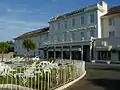 Hotel L'Emeraude, St Helier taken by DS Pugh on 14 August 2001
 Commercial Buildings, St Helier, taken by Colin Park on 20 July 2005
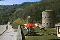
 Noirmont Tower, taken by Bob Embleton on 12 August 2009
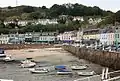 Gorey Harbour, taken by Bob Embleton on 12 August 2009
References
This article is issued from Wikipedia. The text is licensed under Creative Commons - Attribution - Sharealike. Additional terms may apply for the media files.