Geratal | |
|---|---|
Location of Geratal within Ilm-Kreis district 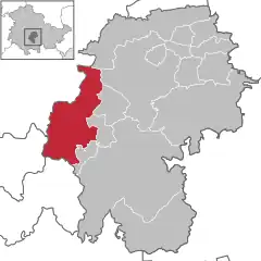 | |
 Geratal 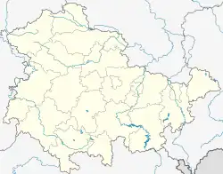 Geratal | |
| Coordinates: 50°45′N 10°49′E / 50.750°N 10.817°E | |
| Country | Germany |
| State | Thuringia |
| District | Ilm-Kreis |
| Subdivisions | 6 |
| Area | |
| • Total | 82.33 km2 (31.79 sq mi) |
| Elevation | 490 m (1,610 ft) |
| Population (2022-12-31)[1] | |
| • Total | 8,789 |
| • Density | 110/km2 (280/sq mi) |
| Time zone | UTC+01:00 (CET) |
| • Summer (DST) | UTC+02:00 (CEST) |
| Postal codes | 98716, 99330, 99338 |
| Dialling codes | 036205, 036207, 03677 |
| Vehicle registration | IK |
Geratal is a municipality in the district Ilm-Kreis, in Thuringia, Germany. It was created with effect from 1 January 2019 by the merger of the former municipalities of Frankenhain, Geraberg, Geschwenda, Gossel, Gräfenroda and Liebenstein. The name refers to the river Gera.
References
Towns and municipalities in Ilm-Kreis | ||
|---|---|---|
Coat of arms | ||
This article is issued from Wikipedia. The text is licensed under Creative Commons - Attribution - Sharealike. Additional terms may apply for the media files.