| Gifford Guyot | |
|---|---|
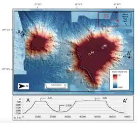
 Gifford Marine Park seabed and profile | |
| Location | |
| Location | Coral Sea |
| Coordinates | 26°22′00″S 159°37′00″E / 26.366667°S 159.61667°E |
| Geology | |
| Type | Seamount |
The Lord Howe Seamount Chain of which Gifford Guyot is an eruptive centre, and part of a pair of coral-capped guyots, formed during the Miocene.[1][2] The Gifford Marine Park is co-located off the Queensland coast near Brisbane.
Geology
The Gifford guyots are two flat‐topped basaltic[3] seamounts, now caped with carbonate sediments with the larger Gifford Guyot dated at 15.6 million years ago[3] but the smaller unnamed seamount of unknown age. They both raise from an abyssal plain 3.4 km (2.1 mi) below sea level to generally flat summits that are about 250 m (820 ft) below sea level. This summit plateau is about 55 km2 (21 sq mi) for the unnamed guyot), and 350 km2 (140 sq mi) in area for Gifford Guyot itself.[4]
See also
References
- ↑ Willem J. M. van der Linden, Morphology of the Tasman sea floor. New Zealand Journal of Geology and Geophysics. Vol.13 (1970) 282-291.
- ↑ Seton, Maria; Williams, Simon; Mortimer, Nick; Meffre, Sebastien; Micklethwaite, Steven; Zahirovic, Sabin (2019-01-22). "Magma production along the Lord Howe Seamount Chain, northern Zealandia". Geological Magazine. 156 (9): 1605–1617. Bibcode:2019GeoM..156.1605S. doi:10.1017/S0016756818000912. ISSN 0016-7568. S2CID 134379148.
- 1 2 Dadd, Kelsie; Locmelis, Marek; Higgins, K; Hashimoto, Riko; Daniell, James (2011). "Cenozoic volcanism in the Capel-Faust Basins, northern Lord Howe Rise" (PDF). Deep-Sea Research Part II. 58: 922–932. doi:10.1016/j.dsr2.2010.10.048.
- ↑ Nanson, Rachel; Carroll, Andrew; Huang, Zhi; Nichol, Scott; Miller, Karen (2018). "An eco-narrative of Gifford Marine Park –Temperate East marine region" (PDF). pp. 1–14.
This article is issued from Wikipedia. The text is licensed under Creative Commons - Attribution - Sharealike. Additional terms may apply for the media files.