
Spring, 2005
Glen Auldyn is a narrow valley about 6 kilometres (3.7 mi) long on the Isle of Man, with a river of the same name. This flows in a NNE direction and flows into the River Sulby not far from its estuary, near Ramsey. It is entirely within the parish of Lezayre. The lower one-third of the valley is inhabited and is partly followed by the B16 road. This section is overlooked by Sky Hill.
The middle section of the valley contains a ribbon of mature oak woodland.[1]
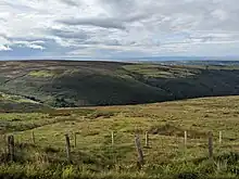
The glen from above
The valley contains the small church of St Fingan.[2]

St Fingan Chapel, Glen Auldyn
In the valley is an underground reservoir with a capacity of around 6,800 cubic metres (240,000 cu ft) which supplies the north and east of the island.[3]
References
- ↑ Manx Wildlife Trust
- ↑ "BBC: Domesday Reloaded". Archived from the original on 29 January 2012. Retrieved 29 January 2012.
- ↑ BBC: Opening of reservoir
54°18′12″N 4°25′17″W / 54.3034°N 4.4213°W
This article is issued from Wikipedia. The text is licensed under Creative Commons - Attribution - Sharealike. Additional terms may apply for the media files.