Gmina Gaworzyce
Gaworzyce Commune | |
|---|---|
 Flag  Coat of arms | |
 | |
| Coordinates (Gaworzyce): 51°37′41″N 15°52′50″E / 51.62806°N 15.88056°E | |
| Country | |
| Voivodeship | Lower Silesian |
| County | Polkowice |
| Seat | Gaworzyce |
| Area | |
| • Total | 76.99 km2 (29.73 sq mi) |
| Population (2019-06-30[1]) | |
| • Total | 3,997 |
| • Density | 52/km2 (130/sq mi) |
| Website | http://www.gaworzyce.com.pl/ |
Gmina Gaworzyce is a rural gmina (administrative district) in Polkowice County, Lower Silesian Voivodeship, in south-western Poland. Its seat is the village of Gaworzyce, which lies approximately 20 kilometres (12 mi) north-west of Polkowice, and 98 kilometres (61 mi) north-west of the regional capital Wrocław.
The gmina covers an area of 76.99 square kilometres (29.7 sq mi), and as of 2019 its total population is 3,997.
Neighbouring gminas
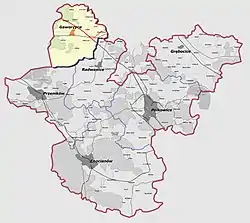
Gmina Gaworzyce is bordered by the gminas of Niegosławice, Przemków, Radwanice and Żukowice.
Villages
The gmina contains the villages of Dalków, Dzików, Gaworzyce, Gostyń, Grabik, Kłobuczyn, Korytów, Koźlice, Kurów Wielki, Mieszków, Śrem, Wierzchowice and Witanowice.
References
- ↑ "Population. Size and structure and vital statistics in Poland by territorial division in 2019. As of 30th June". stat.gov.pl. Statistics Poland. 2019-10-15. Retrieved 2020-02-14.
| Seat | ||
|---|---|---|
| Other villages | ||
Seat: Polkowice | ||
| Urban-rural gminas |  | |
| Rural gminas | ||
This article is issued from Wikipedia. The text is licensed under Creative Commons - Attribution - Sharealike. Additional terms may apply for the media files.