Govi-Altai Province
Говь-Алтай аймаг Gowi-Altai aimag ᠭᠣᠪᠢᠠᠯᠲᠠᠢᠠᠶᠢᠮᠠᠭ | |
|---|---|
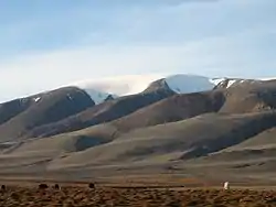
 Sutai Mount (Sutay Uul) in the western part of Govi-Altai Province | |
 Flag  Coat of arms | |
 | |
| Coordinates: 45°30′N 95°30′E / 45.500°N 95.500°E | |
| Country | Mongolia |
| Established | 1940 |
| Capital | Altai City |
| Area | |
| • Total | 141,447.67 km2 (54,613.25 sq mi) |
| Highest elevation | 3,802 m (12,474 ft) |
| Population (2017) | |
| • Total | 57,440 |
| • Density | 0.41/km2 (1.1/sq mi) |
| Time zone | UTC+7 |
| Area code | +976 (0)148 |
| ISO 3166 code | MN-065 |
| Vehicle registration | ГА_ |
| Website | www |
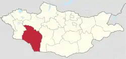
Govi-Altai (Mongolian: Говь-Алтай / Gowi-Altai, pronounced [ˌɡœw̜‿aɬˈtʰæˑ]) is an aimag (province) in western Mongolia.
Transportation
The Altai Airport (LTI/ZMAT) has one paved runway and is served by regular flights to Arvaikheer, Bayankhongor and Ulaanbaatar. The new arrival/departure building was opened to the public in 2013.
Administrative subdivisions

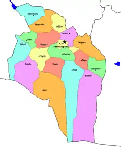
Sums of Govi-Altai
The capital Altai is geographically located in Yesönbulag sum, and not to be confused with the Altai sum in the south of the aimag.
| Sum | Mongolian | Area (km2)[1] |
Population 2007(est.)[1] |
Population 2009(est.)[2] |
Density (/km2) |
Distance from Altai city (km)[1] |
|---|---|---|---|---|---|---|
| Altai | Алтай | 20,256 | 2,386 | 2,152 | 0.11 | 318 |
| Bayan-Uul | Баян-Уул | 5,836 | 2,953 | 2,943 | 0.50 | 146 |
| Biger | Бигэр | 3,826 | 2,460 | 2,197 | 0.57 | 108 |
| Bugat | Бугат | 9,921 | 2,461 | 2,257 | 0.23 | 219 |
| Chandmani | Чандмань | 4,629 | 2,024 | 2,053 | 0.44 | 189 |
| Darvi | Дарви | 3,523 | 1,877 | 1,819 | 0.52 | 212 |
| Delger | Дэлгэр | 6,625 | 3,066 | 3,104 | 0.47 | 88 |
| Erdene | Эрдэнэ | 26,066 | 2,280 | 2,288 | 0.09 | 223 |
| Khaliun | Халиун | 4,214 | 2,546 | 2,497 | 0.59 | 87 |
| Khökh morit | Хөх морьт | 6,314 | 2,404 | 2,461 | 0.39 | 215 |
| Jargalan | Жаргалан | 3,683 | 1,885 | 1,904 | 0.52 | 102 |
| Sharga | Шарга | 5,566 | 1,930 | 1,921 | 0.35 | 79 |
| Taishir | Тайшир | 3,913 | 1,575 | 1,536 | 0.39 | 43 |
| Tögrög | Төгрөг | 5,343 | 1,871 | 1,914 | 0.36 | 148 |
| Tonkhil | Тонхил | 7,322 | 2,388 | 2,402 | 0.33 | 218 |
| Tseel | Цээл | 5,631 | 2,235 | 2,038 | 0.36 | 167 |
| Tsogt | Цогт | 16,618 | 3,950 | 3,697 | 0.22 | 187 |
| Yesönbulag* | Есөнбулаг | 2,161 | 17,527 | 16,243 | 7.52 | 0 |
*Includes the capital of Govi-Altai Aimag, Altai City.
Notes
- 1 2 3 Govi-Altai aimag official site Archived 2011-07-22 at the Wayback Machine
- ↑ Govi-Altai aimag statistical office annual report 2009 Archived 2011-07-22 at the Wayback Machine
Wikimedia Commons has media related to Govi-Altai Aimag.
This article is issued from Wikipedia. The text is licensed under Creative Commons - Attribution - Sharealike. Additional terms may apply for the media files.
