| Gorbeia Natural Park | |
|---|---|
| |
IUCN category V (protected landscape/seascape) | |
 The fields of Arraba, with Lekanda in the background | |
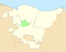
 Location within the Basque Country | |
| Location | Álava and Biscay, Basque Country, Spain |
| Coordinates | 43°02′06″N 2°49′01″W / 43.035°N 2.817°W |
| Area | 200.16 km2 (77.28 sq mi) |
| Established | 21 June 1994 |
Natura 2000 site (SAC) | |
| Official name | Gorbeia |
| Designated | May 2016 |
| Reference no. | ES2110009[1] |
| Area | 202.26 km2 (78.09 sq mi) |
The Gorbeia Natural Park (Basque: Gorbeiako natura parkea, Spanish: Parque natural del Gorbeia) is the largest in the Basque Country, Spain. The park is located in the municipalities of Orozko, Zeberio and Zeanuri in Biscay and Zigoitia, Zuia and Urkabustaiz in Álava. With a surface area of 200 km2 (77 sq mi), it covers the Gorbeia massif, which is the highest summit in Álava and Biscay. The park was established by decree of the Basque Government in 1994.[2]
Geography
The park is cenetered on mount Gorbeia and the massif of the same name. The summit, with a height of 1,482 m (4,862 ft), is the highest in the provinces of Álava and Biscay. This has made it one of the most emblematic summits of the Basque Country.[3][4]
References
- ↑ "Site factsheet for Gorbeia". EUNIS. European Environment Agency. Retrieved 14 October 2022.
- ↑ "DECRETO 228/1994, de 21 de junio, por el que se declara Parque Natural el área de Gorbeia" (PDF). BOPV (in Spanish and Basque) (154): 9591–9598. 16 August 1994.
- ↑ J. Pérez, Fernando (14 November 2021). "La cruz del Gorbea: 120 años como faro del montañismo" (in Spanish).
- ↑ Molano, Eva (13 November 2021). "La Cruz del Gorbea, querida por todos". El Correo (in Spanish). Retrieved 25 September 2022.
External links
 Media related to Gorbeia Natural Park at Wikimedia Commons
- Official website
 Geographic data related to Gorbeia Natural Park at OpenStreetMap
This article is issued from Wikipedia. The text is licensed under Creative Commons - Attribution - Sharealike. Additional terms may apply for the media files.