Gosen-Neu Zittau | |
|---|---|
Location of Gosen-Neu Zittau within Oder-Spree district 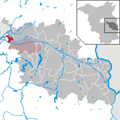 | |
 Gosen-Neu Zittau  Gosen-Neu Zittau | |
| Coordinates: 52°23′36″N 13°42′46″E / 52.39333°N 13.71278°E | |
| Country | Germany |
| State | Brandenburg |
| District | Oder-Spree |
| Municipal assoc. | Spreenhagen |
| Subdivisions | 4 districts |
| Government | |
| • Mayor (2019–24) | Thomas Schwedowski[1] (SPD) |
| Area | |
| • Total | 15.07 km2 (5.82 sq mi) |
| Elevation | 37 m (121 ft) |
| Population (2021-12-31)[2] | |
| • Total | 3,318 |
| • Density | 220/km2 (570/sq mi) |
| Time zone | UTC+01:00 (CET) |
| • Summer (DST) | UTC+02:00 (CEST) |
| Postal codes | 15537 |
| Dialling codes | 03362 |
| Vehicle registration | LOS |
| Website | www.amt-spreenhagen.de |
Gosen-Neu Zittau is a municipality in the Oder-Spree district, in Brandenburg, Germany. Neu Zittau is situated in the Spree valley, near the Oder-Spree-Canal.
Geography
Neighbouring places
Division of the town
- Gosen
- Neu Zittau
- Burig
- Steinfurt
Demography
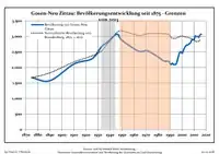
Development of population since 1875 within the current boundaries (Blue line: Population; Dotted line: Comparison to population development of Brandenburg state; Grey background: Time of Nazi rule; Red background: Time of communist rule)
|
|
References
- ↑ Landkreis Oder-Spree Wahl der Bürgermeisterin / des Bürgermeisters, accessed 2 July 2021.
- ↑ "Bevölkerungsentwicklung und Flächen der kreisfreien Städte, Landkreise und Gemeinden im Land Brandenburg 2021" (PDF). Amt für Statistik Berlin-Brandenburg (in German). June 2022.
- ↑ Detailed data sources are to be found in the Wikimedia Commons.Population Projection Brandenburg at Wikimedia Commons
Towns and municipalities in Oder-Spree | ||
|---|---|---|
| Coat of Arms of Oder-Spree district | |
This article is issued from Wikipedia. The text is licensed under Creative Commons - Attribution - Sharealike. Additional terms may apply for the media files.