40°40′31″N 73°59′28″W / 40.6753°N 73.9911°W

Gowanus (/ɡəˈwɑːnəs/ gə-WAH-nəs) is a neighborhood in the northwestern portion of the New York City borough of Brooklyn, within the area once known as South Brooklyn. The neighborhood is part of Brooklyn Community District 6. Gowanus is bounded by Wyckoff Street on the north, Fourth Avenue on the east, the Gowanus Expressway to the south, and Bond Street to the west.[1]
History
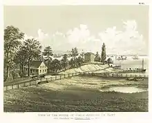
In 1636, Gowanus Bay – named after Gauwane (Gouwane, lit. "the sleeper"), a Canarsee Indian[2][3] – was the site of the first settlement by Dutch farmers in what is now Brooklyn.[4] The ponds of Gowanus meadowlands served to drive early settlers' tide-powered gristmills which were situated along the Gowanus Creek. During the American Revolutionary War, Gowanus was the scene of fighting in the Battle of Long Island and American soldiers positioned themselves in Gowanus Heights (now Park Slope), where they had full view of the British ships as they made landfall in the Bay.[5][6]

In the 1860s the Gowanus Creek was turned into the Gowanus Canal, and the area became a hub for manufacturing and shipping. As a result of the industry along the canal and the establishment of a combined sewer system that dumped waste water directly into a designated outflow at the head of the canal, the neighborhood came to be defined by the polluted canal.[7] After World War II, the decline of shipping at the port of Red Hook and of manufacturing around New York City prompted large industry to leave and changed the vibrancy of industry in Gowanus. In the late 1940s, the neighborhood became the site of several NYCHA housing projects, which were built in part to house returning WWII veterans.[8]
The water and much of the land along the banks of the Gowanus Canal have been severely polluted by combined sewer outflows (CSOs) along the canal designed to relieve sewage and storm water when the sewer treatment plant is overwhelmed, as well as by decades of industrial use and extensive coal gas manufacturing during the late 19th century. The Gowanus Canal was also an alleged Mafia dumping ground.[9] Even so, in the early 1980s, alongside the canal, an old 19th-century munitions factory at 230 3rd Street in Gowanus became the site of the massive Gowanus Memorial Artyard, whose remains are still visible.[10] After decades of industrial pollution combined with sewage contamination, the Environmental Protection Agency designated the Gowanus Canal a Superfund site in 2010, allocating $506 million for the cleanup.[11] The completion date for the cleanup is set for 2022.[12]
21st century

The area is zoned for light to mid-level manufacturing.[13] In the first decade of the 21st century, residential developers were hindered by the industrial zoning and the problems of the sewage overflow through the canal water, but there have been rumors of rezoning by the New York City Department of City Planning.[14] Many residents and community groups have expressed concern over the sewage overflow that the rezoning could possibly create.[11] From 2013–2016, the City Planning Department, community groups, business owners, developers, arts organizations, and neighborhood residents participated in a "community planning process" called Bridging Gowanus intended to inform neighborhood rezoning processes with the intention of creating a land-use framework for the neighborhood.[15]

Many "coworking" spaces were formed in Gowanus in the 2010s.[16] More restaurants, bars, and art galleries moved to the neighborhood, and new real estate became available.[17]
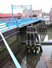
On the New York City Subway, the D, N, R, and W trains on the BMT Fourth Avenue Line and the F, <F>, and G trains on the IND Culver Line run through Gowanus. Bike routes cross the canal on the Union Street, 3rd Street and 9th Street bridges.[18] The elevated Gowanus Expressway runs through the southern edge of the neighborhood, crossing the canal at Hamilton Avenue. The Carroll Street Bridge, built in 1889, is the oldest of the four remaining retractable bridges in the country.[19]
References
- ↑ Jackson, Kenneth T. (1998). Neighborhoods of Brooklyn. Yale University Press. p. 137.
- ↑ Bolton, Reginald Pelham (1920). New York City in Indian possession. Museum of the American Indian. p. 135.
Canarsee [...] Gauwane: The owner of the Gowanus tract in Brooklyn, which still bears his name.
- ↑ William Wallace Tooker; John Jermain Memorial Library (Sag Harbor, N.Y.) (1911). The Indian Place-names on Long Island and Islands Adjacent. G.P. Putnam's Sons. p. 66.
the land probably takes its name from the Indian who planted there, Gauwane's plantation. His name may be translated 'the sleeper,' or 'he rests.' It is cognate with the Delaware gauwin, "to sleep;" Massachusett kouweu, "he sleeps," kouéuénin, "a sleeper."
- ↑ Stiles, Henry R. (1867). A History of the City of Brooklyn. p. 23. Retrieved 2010-07-04.
- ↑ Lewis, Charles. Cut Off: Colonel Jedediah Huntington's 17th Continental (Conn.) Regiment at the Battle of Long Island August 27, 1776. p. 93.
- ↑ Schecter, Barnet (2006). "Battle of Long Island, New York." Encyclopedia of the American Revolution: Library of Military History. Ed. Harold E. Selesky. Vol. 1. Charles Scribner's Sons. pp. 646–655.
- ↑ Alexiou, Joseph (2015). Gowanus: Brooklyn's Curious Canal. NYU Press. ISBN 9781479892945.
- ↑ "Officials Start Work on Gowanus Houses". Brooklyn Daily Eagle. Jan 5, 1948.
- ↑ Warshawer, Gabby (January 2, 2007). "Close-Up on Gowanus, Brooklyn". The Village Voice. Archived from the original on 2010-08-05. Retrieved 2010-07-04.
- ↑ "Once Upon a Time on the Shores of the Gowanus: Frank Shifreen and "The Monument Redefined" Show". October 16, 2007. Retrieved 2010-11-30.
- 1 2 Rugh, Peter. "NYC's Latest Luxury Scheme Could Leave Gowanus Residents in a Foul Place". The Indypendent. Retrieved July 11, 2019.
- ↑ Attanasio, Cedar; Jaeger, Max (August 13, 2018). "Gowanus Canal cleanup has unearthed historic treasures — covered in toxic goo". New York Post. Retrieved August 15, 2018.
- ↑ "Gowanus Canal Corridor Framework". New York City Department of City Planning. Archived from the original on 2010-05-29. Retrieved 2010-07-04.
- ↑ Kim, Janet (February 18, 2003). "Close-Up on Gowanus". The Village Voice. Archived from the original on May 16, 2011. Retrieved 2010-07-04.
- ↑ "Bridging Gowanus: Executive Summary". Bridging Gowanus. September 2015. Retrieved January 9, 2018.
- ↑ Albrecht, Leslie (12 June 2015). "Co-Working Spaces Booming in Gowanus as More Workers Shun Offices". DNA Info. Archived from the original on 22 June 2015. Retrieved 20 June 2015.
- ↑ Mosendz, Polly (4 April 2014). "NEIGHBORHOOD SECRETS GOWANUS, BROOKLYN: THE INSIDER'S GUIDE TO LIVING THERE". Brick underground. Retrieved 10 April 2014.
- ↑ NYC Department of Transportation. "List of Bicycle Lanes in Roadways". NYC.gov. New York City. Archived from the original on 12 March 2013. Retrieved 11 January 2013.
- ↑ Gray, Christopher (May 21, 1989). "The Carroll Street Bridge; Getting a Landmark in Shape for Its 100th Birthday". The New York Times. Retrieved 2010-07-04.
External links
 Media related to Gowanus, Brooklyn at Wikimedia Commons
 Gowanus and Red Hook travel guide from Wikivoyage
