Grafenegg | |
|---|---|
 Coat of arms | |
 Grafenegg Location within Austria | |
| Coordinates: 48°26′N 15°45′E / 48.433°N 15.750°E | |
| Country | Austria |
| State | Lower Austria |
| District | Krems-Land |
| Government | |
| • Mayor | Manfred Denk (ÖVP) |
| Area | |
| • Total | 28.53 km2 (11.02 sq mi) |
| Elevation | 197 m (646 ft) |
| Population (2018-01-01)[2] | |
| • Total | 3,061 |
| • Density | 110/km2 (280/sq mi) |
| Time zone | UTC+1 (CET) |
| • Summer (DST) | UTC+2 (CEST) |
| Postal code | 3492 |
| Area code | 02735 |
Grafenegg is a market town (Municipality) in the Krems-Land district of Lower Austria, Austria.
History
Originally called Etsdorf-Haitzendorf, it changed its name in 2003.
Population
| Year | Pop. | ±% |
|---|---|---|
| 1971 | 2,713 | — |
| 1981 | 2,621 | −3.4% |
| 1991 | 2,687 | +2.5% |
| 2001 | 2,830 | +5.3% |
| 2011 | 2,982 | +5.4% |
| 2021 | 3,197 | +7.2% |
Sights

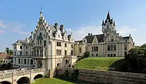
Grafenegg Castle
Grafenegg is renowned for Schloss Grafenegg, owned by the Duke of Ratibor, Prince of Corvey of the House of Hohenlohe. The castle grounds are the site of the Grafenegg Music Festival and sculpture garden.
References
- ↑ "Dauersiedlungsraum der Gemeinden Politischen Bezirke und Bundesländer - Gebietsstand 1.1.2018". Statistics Austria. Retrieved 10 March 2019.
- ↑ "Einwohnerzahl 1.1.2018 nach Gemeinden mit Status, Gebietsstand 1.1.2018". Statistics Austria. Retrieved 9 March 2019.
This article is issued from Wikipedia. The text is licensed under Creative Commons - Attribution - Sharealike. Additional terms may apply for the media files.
