 Night view of Granville Street, Downtown (2018) | |
| Part of | |
|---|---|
| Namesake | Granville Leveson-Gower, 2nd Earl Granville |
| Type | Street |
| Length | 9.8 km (6.1 mi)[1] |
| Location | Vancouver, British Columbia |
| Nearest metro station | |
| South end | SW Marine Drive |
| Major junctions | 70th Avenue 41st Avenue Broadway Seymore Street/Howe Street Georgia Street Hastings Street |
| North end | Cordova Street |
| Other | |
| Known for | Shopping districts, Granville Entertainment District, Granville Mall, Granville Island, South Granville |

Granville Street is a major street in Vancouver, British Columbia, Canada, and part of Highway 99. Granville Street is most often associated with the Granville Entertainment District and the Granville Mall. This street also cuts through residential neighbourhoods like Shaughnessy and Marpole via the Granville Street Bridge.
Location

Granville Street runs generally north–south through the centre of Vancouver, passing through several neighbourhoods and commercial areas, differing appreciably in their land value and the wealth of their residents.
Granville runs northeast–southwest:
- through Downtown Vancouver from the waterfront area (including Waterfront station) at West Cordova Street to Robson Street
- through a pedestrian-friendly area known as the Granville Mall with part of it formally designated as the Granville Entertainment District (ending at the Granville Street Bridge); here, numerous shops, restaurants, and the city's top dance clubs, bars and entertainment venues are located
- over the Granville Street Bridge
- over Granville Island (located under the bridge)
Then, Granville Street runs north–south:
- through South Granville Rise, extending approximately from 4th Avenue to 16th Avenue, crossing West Broadway
- through Shaughnessy (from 16th Avenue to 41st Avenue)
- near Kerrisdale and Oakridge (Granville borders both neighbourhoods from 41st Avenue to 57th Avenue; unofficially, Kerrisdale begins at 33rd Avenue)
- through Marpole (from 57th Avenue to 70th Avenue; 70th Avenue becomes Southwest Marine Drive west of Granville)
- near the Fraser River, where it merges with another section of South-West Marine Drive
Finally, Granville Street ends near the Fraser River at the approximate location of 72nd Ave., then merges with Southwest Marine Drive and continues southeasterly towards the Arthur Laing Bridge that leads to Richmond and the Vancouver International Airport.
History
19th century
The community was known as "Gastown" (Gassy's Town) after its first citizen - Jack Deighton, known as "Gassy" Jack. "To gas" is period English slang for "to boast and to exaggerate". In 1870, the community was laid out as the "township of Granville" but everybody called it Gastown. The name Granville honours Granville Leveson-Gower, 2nd Earl Granville, who was British Secretary of State for the Colonies at the time of local settlement.
In 1886, it was incorporated as the city of Vancouver, named after Captain George Vancouver, who accompanied James Cook on his voyage to the West Coast and subsequently spent two years exploring and charting the West Coast.
20th century
Towards the middle of the twentieth century, the downtown portion of Granville Street had become a flourishing centre for entertainment, known for its cinemas (built along the "Theatre Row", from the Granville Bridge to where Granville Street intersects Robson Street), restaurants, clubs, the Vogue and Orpheum theatres, and, later, arcades, pizza parlours, pawn stores, pornography shops and strip clubs.[2]
By the late 1990s, Granville Street suffered gradual deterioration and many movie theatres, such as "The Plaza, Caprice, Paradise, [and] Granville Centre [...] have all closed for good", writes Dmitrios Otis in his article "The Last Peep Show." In the early 2000s, the news of the upcoming 2010 Winter Olympic Games, to be hosted in Whistler, a series of gentrification projects, still ongoing as of 2006, had caused the shutdown of many more businesses that had heretofore become landmarks of the street and of the city.[2]
21st century
Also, Otis writes that "once dominated by movie theatres, pinball arcades, and sex shops [Downtown Granville is being replaced] by nightclubs and bars, as [... it] transforms into a booze-based 'Entertainment District'." In April 2005, Capitol 6, a beloved 1920s-era movie theatre complex (built in 1921 and restored and reopened in 1977) closed its doors (Chapman). By August 2005, Movieland Arcade, located at 906 Granville Street became "the last home of authentic, 8 mm 'peep show' film booths in the world" (Otis). On July 7, 2005, the Granville Book Company, a popular and independently owned bookstore was forced to close (Tupper) due to the rising rents and regulations the city began imposing in the early 2000s in order to "clean up" the street by the 2010 Olympics and combat Vancouver's "No Fun City" image. (Note the "Fun City" red banners put up by the city on the lamp-posts in the pizza-shop photograph). Landlords have been unable to find replacement tenants for many of these closed locations; for example, the Granville Book Company site was still boarded up and vacant as of July 12, 2006.
While proponents of the Granville gentrification project in general (and the 2010 Olympics in specific) claim that the improvements made to the street will only benefit its residents, the customers frequenting the clubs and the remaining theatres and cinemas, maintain that the project is a temporary solution, since the closing down of the less "classy" businesses, and the build-up of Yaletown-style condominiums in their place, will not eliminate the unwanted pizzerias, corner-stores and pornography shops - and their patrons - but will simply displace them elsewhere (an issue reminiscent of the city's long-standing inability to solve the problems of the DTES).
Major intersections
The entire route is in Vancouver.
| km[1] | mi | Destinations | Notes | ||
|---|---|---|---|---|---|
| −0.5 | −0.31 | Interchange | |||
| 0.0 | 0.0 | Southwest Marine Drive | Granville Street southern terminus; roadway continues south | ||
| 0.4 | 0.25 | South end of Hwy 99 concurrency | |||
| 1.6 | 0.99 | West 57th Avenue | |||
| 2.4 | 1.5 | West 49th Avenue | |||
| 3.2 | 2.0 | Alternate Hwy 99 connection between Oak Street and Granville Street | |||
| 4.1 | 2.5 | West 33rd Avenue | |||
| 4.9 | 3.0 | King Edward Avenue | |||
| 5.8 | 3.6 | West 16th Avenue | |||
| 6.2 | 3.9 | West 12th Avenue | |||
| 8.1 | 5.0 | Hwy 7 western terminus | |||
| 7.0 | 4.3 | West 4th Avenue, Fir Street | Interchange; West 4th Avenue is southbound exit and northbound entrance; Fir Street is southbound exit only | ||
| 7.0– 7.9 | 4.3– 4.9 | Granville Street Bridge over False Creek | |||
| 7.9– 8.1 | 4.9– 5.0 | Interchange; northbound Hwy 99 follows Seymour Street, southbound Hwy 99 follows Howe Street | |||
| 8.4 | 5.2 | Davie Street | |||
| 8.7 | 5.4 | Nelson Street | One-way, southeast-bound; provides access to the Cambie Bridge | ||
| 8.9 | 5.5 | Smithe Street | One-way, northwest-bound; provides access from the Cambie Bridge | ||
| 9.1 | 5.7 | Robson Street | |||
| 9.3 | 5.8 | Former Hwy 1A south / Hwy 99A; near | |||
| 9.4 | 5.8 | Dunsmuir Street | One-way, northwest-bound; near | ||
| 9.6 | 6.0 | Pender Street | |||
| 9.7 | 6.0 | ||||
| Hastings Street | Former Hwy 7A | ||||
| 9.8 | 6.1 | Cordova Street | Across from | ||
1.000 mi = 1.609 km; 1.000 km = 0.621 mi
| |||||
Gallery
 The last few remaining pornography and peep show stores on Granville Street. circa 2005
 The shutdown Granville Book Company, an independently owned Granville Street bookstore. circa 2005
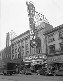
 The Orpheum Theatre with advertising for the movie Lady Luck ; note the Commodore Ballroom on the left. circa 1946
 The beginning of the end: small businesses on Granville Street. circa 2005
 Looking North at 12th and Granville past the Stanley Industrial Alliance Stage.
 The Orpheum Theatre, advertising the Vancouver Symphony Orcherstra
 The Vogue Theatre
 Empty storefronts and rising rents: a common sight on Granville Street in 2005
 Movieland Arcade Street Sign
 SameSun Backpackers' Lodge
Cultural references
- Granville Street is the second-most expensive property in the game Canadian Monopoly.
References and further reading
Current issues
- Chapman, Aaron. "The End." 12 April 2005. The Vancouver Courier.
- "Granville Street Redesign." 14 June 2007. City of Vancouver.
- Stamp, Graeme. "Granville Street Redesign." 18 November 2004. A letter from the Chair and Chief Elected Officer to Mayor Larry Campbell.
- Otis, Dmitrios. "The Last Peep Show." 31 August 2005. The Vancouver Courier.
- Tupper, Peter. "Granville's Closing Chapter." 10 August 2005. The Vancouver Courier.
History
- "1920s Granville Street." 2005. Tom Lee Music Co. Selected photographs of Granville Street from the Vancouver Public Library Archives.
- "Granville Street Redesign History." 14 June 2007. City of Vancouver.
- "Rezoning of 8405–8435 Granville Street." 19 September 1997. City of Vancouver.
- City Lights etc video shows Theatre Row lights at night in 1964. City of Vancouver Archives channel, YouTube.
Listings and tour guides
- "Granville Street." 5 February 2005. Eve Vancouver. A thorough listing of restaurants and businesses on Granville street.
- "Granville Street Clubs – Nightlife - Vancouver Night clubs, Vancouver Bars, Granville Street Shopping." 2006. Weiland Media.
- "Granville Street Walk." 27 August 2001. Walk Vancouver. An (outdated) virtual tour of Granville Street's downtown portion.
- "Vancouver's Granville Street Art Galleries, Restaurants and Shops." 2006. BCPassport. A selected listing of South Granville businesses.
Searchable resources
- Granville Street on Google Maps normal | satellite | hybrid
- "Google Image Search: Granville Street." The search reveals many historical and current photographs of Granville Streets, its locations and denizens.
- "Search Photographs" 29 June 2009. City of Vancouver Archives. Enter "Granville" or "Granville street" (without the quotation marks) into the "Keyword(s)" field.
Citations
- 1 2 Google (July 28, 2021). "Granville Street (Vancouver)" (Map). Google Maps. Google. Retrieved July 28, 2021.
- 1 2 Atkin, John (2003). "Vancouver Neon!". Discover Vancouver. Archived from the original on February 4, 2003. Retrieved July 28, 2021.