Graysville | |
|---|---|
 Graysville Location of Graysville in Manitoba | |
| Coordinates: 49°30′33″N 98°9′27″W / 49.50917°N 98.15750°W | |
| Country | |
| Province | |
| Region | Pembina Valley |
| Census Division | No. 3 |
| Government | |
| • Governing Body | Rural Municipality of Dufferin Council |
| • MP | Candice Bergen |
| • MLA | Blaine Pedersen |
| Time zone | UTC−6 (CST) |
| • Summer (DST) | UTC−5 (CDT) |
| Postal Code | R0G 0T0 |
| Area code(s) | 204, 431 |
| NTS Map | 062G09 |
| GNBC Code | GAJUV |
Graysville is an unincorporated community in south central Manitoba, Canada. It is located approximately 11 kilometers (7 miles) west of Carman, Manitoba[1] in the Rural Municipality of Dufferin.
The Post Office was opened in 1904 on the farm of George Gray where a town site had developed. There was a Gray, Saskatchewan so the name Graysville became the mail name. The community had been known as Grays. The railway point and the school district also assumed the name.
References
- Notes
- ↑ "Geographical Names of Canada - Querying Distances". nrcan.gc.ca. October 24, 2011. Archived from the original on April 16, 2014. Retrieved October 5, 2012.
- Sources
- Geographic Names of Manitoba (pg. 99) - Graysville - the Millennium Bureau of Canada
| Cities | 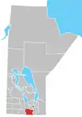 | ||
|---|---|---|---|
| Towns |
| ||
| Rural municipalities |
| ||
| Unincorporated communities | |||
This article is issued from Wikipedia. The text is licensed under Creative Commons - Attribution - Sharealike. Additional terms may apply for the media files.