Greenville, Florida | |
|---|---|
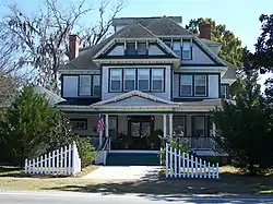 Historic Bishop-Andrews Hotel | |
 Location in Madison County and the state of Florida | |
| Coordinates: 30°28′N 83°38′W / 30.467°N 83.633°W | |
| Country | United States |
| State | |
| County | Madison |
| Area | |
| • Total | 1.32 sq mi (3.41 km2) |
| • Land | 1.32 sq mi (3.41 km2) |
| • Water | 0.00 sq mi (0.00 km2) |
| Elevation | 98 ft (30 m) |
| Population | |
| • Total | 746 |
| • Density | 566.44/sq mi (218.78/km2) |
| Time zone | UTC-5 (Eastern (EST)) |
| • Summer (DST) | UTC-4 (EDT) |
| ZIP code | 32331 |
| Area code | 850 |
| FIPS code | 12-27575[4] |
| GNIS feature ID | 0283426[2] |
| Website | mygreenvillefl |
Greenville is a town in Madison County, Florida, United States. The population was 746 at the 2020 census,[3] down from 843 at the 2010 census.
History
Greenville was established before the American Civil War. It was originally known as Sandy Ford and then as Station Five for its location along the Pensacola and Georgia Railroad. It was incorporated as Greenville in 1907.[5] Ray Charles lived with his mother in Greenville. There is a statue of him in Greenville Park.
Geography
Greenville is located in western Madison County at 30°28′N 83°38′W / 30.467°N 83.633°W (30.467, –83.635).[6] U.S. Route 90 passes through the north side of the town, leading east 13 miles (21 km) to Madison, the county seat, and northwest 16 miles (26 km) to Monticello. U.S. Route 221 passes through the center of town, leading south 26 miles (42 km) to Perry and north 24 miles (39 km) to Quitman, Georgia. Interstate 10 passes 2 miles (3 km) south of the town, with access to US-221 at Exit 241. I-10 leads west 41 miles (66 km) to Tallahassee, the state capital, and east 63 miles (101 km) to Lake City.
According to the United States Census Bureau, the town of Greenville has a total area of 1.3 square miles (3.4 km2), all land.[1]
Demographics
| Census | Pop. | Note | %± |
|---|---|---|---|
| 1910 | 751 | — | |
| 1920 | 668 | −11.1% | |
| 1930 | 904 | 35.3% | |
| 1940 | 1,114 | 23.2% | |
| 1950 | 1,163 | 4.4% | |
| 1960 | 1,318 | 13.3% | |
| 1970 | 1,141 | −13.4% | |
| 1980 | 1,096 | −3.9% | |
| 1990 | 950 | −13.3% | |
| 2000 | 837 | −11.9% | |
| 2010 | 843 | 0.7% | |
| 2020 | 746 | −11.5% | |
| U.S. Decennial Census[7] | |||
2020 census
Note: the US Census treats Hispanic/Latino as an ethnic category. This table excludes Latinos from the racial categories and assigns them to a separate category. Hispanics/Latinos can be of any race.
| Race | Number | Percentage |
|---|---|---|
| White (NH) | 217 | 29.09% |
| Black or African American (NH) | 480 | 64.34% |
| Native American or Alaska Native (NH) | 3 | 0.4% |
| Asian (NH) | 2 | 0.27% |
| Some Other Race (NH) | 2 | 0.27% |
| Mixed/Multi-Racial (NH) | 23 | 3.08% |
| Hispanic or Latino | 19 | 2.55% |
| Total | 746 |
As of the 2020 United States census, there were 746 people, 329 households, and 199 families residing in the town.
2000 census
As of the census[4] of 2000, there were 837 people, 331 households, and 220 families residing in the town. The population density was 636.9 inhabitants per square mile (245.9/km2). There were 394 housing units at an average density of 299.8 per square mile (115.8/km2). The racial makeup of the town was 27.36% White, 72.04% African American, 0.12% Native American, 0.12% Asian, 0.12% from other races, and 0.24% from two or more races. Hispanic or Latino of any race were 0.24% of the population.
There were 331 households, out of which 33.8% had children under the age of 18 living with them, 33.8% were married couples living together, 27.5% had a female householder with no husband present, and 33.5% were non-families. 31.4% of all households were made up of individuals, and 16.9% had someone living alone who was 65 years of age or older. The average household size was 2.53 and the average family size was 3.16.
In the town, the population was spread out, with 31.3% under the age of 18, 7.2% from 18 to 24, 24.4% from 25 to 44, 19.0% from 45 to 64, and 18.2% who were 65 years of age or older. The median age was 35 years. For every 100 females, there were 83.2 males. For every 100 females age 18 and over, there were 70.1 males.
The median income for a household in the town was $20,060, and the median income for a family was $21,484. Males had a median income of $23,750 versus $17,368 for females. The per capita income for the town was $11,128. About 26.4% of families and 32.9% of the population were below the poverty line, including 48.5% of those under age 18 and 25.7% of those age 65 or over.
Education

Greenville Elementary School is a part of the District School Board of Madison County. Secondary school students go to the PreK–8 Madison County Central School, which serves Greenville students for middle school, and Madison County High School.
The Suwanee River Regional Library System operates the Greenville Library.[9]
Notable people
- Ray Charles, childhood home of R&B icon
- Geno Hayes, linebacker for Florida State, Tampa Bay Buccaneers, Chicago Bears and Jacksonville Jaguars
- Chris Thompson, running back for Florida State, Washington Redskins, and the Jaguars
References
- 1 2 "2022 U.S. Gazetteer Files: Florida". United States Census Bureau. Retrieved December 14, 2022.
- 1 2 U.S. Geological Survey Geographic Names Information System: Greenville, Florida
- 1 2 "P1. Race – Greenville town, Florida: 2020 DEC Redistricting Data (PL 94-171)". U.S. Census Bureau. Retrieved December 14, 2022.
- 1 2 "U.S. Census website". United States Census Bureau. Retrieved January 31, 2008.
- ↑ https://www.florida-backroads-travel.com/greenville-florida.html#:~:text=GREENVILLE%2C%20FLORIDA%20HISTORY,the%20Pensacola%20and%20Georgia%20Railroad.
- ↑ "US Gazetteer files: 2010, 2000, and 1990". United States Census Bureau. February 12, 2011. Retrieved April 23, 2011.
- ↑ "Decennial Census of Population and Housing by Decades". US Census Bureau.
- ↑ "Explore Census Data". data.census.gov. Retrieved March 7, 2022.
- ↑ "Greenville." Suwanee River Regional Library System. Retrieved on April 8, 2017.
External links
- Official website
- http://users.wildblue.net/pricec123/ray_charles_memorial.htm%5B%5D
- Preservation Magazine's article on the Ray Charles Childhood Home
Municipalities and communities of Madison County, Florida, United States | ||
|---|---|---|
| City |  | |
| Towns | ||
| Unincorporated communities | ||