Großkarolinenfeld | |
|---|---|
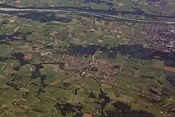 Aerial view | |
 Coat of arms | |
Location of Großkarolinenfeld within Rosenheim district 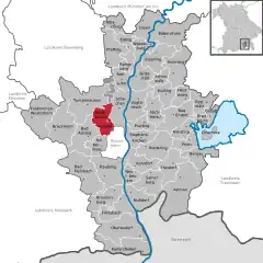 | |
 Großkarolinenfeld  Großkarolinenfeld | |
| Coordinates: 47°53′27″N 12°4′47″E / 47.89083°N 12.07972°E | |
| Country | Germany |
| State | Bavaria |
| Admin. region | Oberbayern |
| District | Rosenheim |
| Government | |
| • Mayor (2020–26) | Bernd Fessler[1] |
| Area | |
| • Total | 29.73 km2 (11.48 sq mi) |
| Elevation | 467 m (1,532 ft) |
| Population (2022-12-31)[2] | |
| • Total | 7,443 |
| • Density | 250/km2 (650/sq mi) |
| Time zone | UTC+01:00 (CET) |
| • Summer (DST) | UTC+02:00 (CEST) |
| Postal codes | 83109 |
| Dialling codes | 08031 |
| Vehicle registration | RO |
| Website | www |

Großkarolinenfeld (spelled with the German ß) is a municipality in the district of Rosenheim in Bavaria in Germany.
It is located at the Munich–Rosenheim railway. The Großkarolinenfeld station is served about once per hour by local trains of the company Bayerische Regiobahn.[3]
There are 41 official boroughs of Großkarolinenfeld. The larger ones are Großkarolinenfeld itself, Jarezöd (also known as Dred), Hilperting, Tattenhausen and Thann, the smaller ones are mostly farmsteads, namely Alsterloh, Ametsbichl, Aschach, Auberg, Bach, Bichl, Buchrain, Deutlstätt, Ester, Filzen, Frauenholz, Gröben, Gutmart, Haslau, Hohenaich, Hub, Kirchsteig, Kolberg, Krabichl, Lehen, Linden, Mühlbach, Naglstätt, Öd, Ödenhub, Petzenbichl, Rann, Ried, Riedhof, Rott, Schlimmerstätt, Schwaig, Stolz, Thonbichl, Vogl, and Zweckstätt.[4]
Three rivers are located in the borough of Großkarolinenfeld: The Aschach[5][6] and the Erlbach[5][7] discharge into the Rott.
History
In 1802, the Catholic Maximilian I Joseph of Bavaria and his Protestant wife Caroline of Baden decreed that people from the Electoral Palatinate may settle down in some places at the Old Bavarian Donaumoos. One of these places was the new municipality of Großkarolinenfeld.[8] In 1882, the first Protestant church in Altbayern was erected here.[8]
References
- ↑ Liste der ersten Bürgermeister/Oberbürgermeister in kreisangehörigen Gemeinden, Bayerisches Landesamt für Statistik, 15 July 2021.
- ↑ Genesis Online-Datenbank des Bayerischen Landesamtes für Statistik Tabelle 12411-003r Fortschreibung des Bevölkerungsstandes: Gemeinden, Stichtag (Einwohnerzahlen auf Grundlage des Zensus 2011)
- ↑ Map of the railway network by the Bayerische Regiobahn, schedule (in German)
- ↑ Bayerische Landesbibliothek Online
- 1 2 Topographische Karte 1:25000 8138 Rosenheim (Map) (1. ed.). 1:25000. Landesamt für Vermessung und Geoinformation Bayern. 2006. ISBN 978-3-86038-043-7.
- ↑ Google (17 February 2018). "Aschach" (Map). Google Maps. Google. Retrieved 17 February 2018.
- ↑ Google (17 February 2018). "Erlbach" (Map). Google Maps. Google. Retrieved 17 February 2018.
- 1 2 Greiner, Heribert (2002). Großkarolinenfeld 1802-2002 (in German). Großkarolinenfeld: Gemeinde Großkarolinenfeld. pp. 5ff.