Grosbous
Groussbus, Bus | |
|---|---|
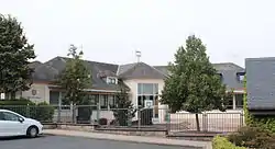 Town hall | |
 Coat of arms | |
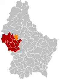 Map of Luxembourg with Grosbous highlighted in orange, and the canton in dark red | |
| Coordinates: 49°50′00″N 5°58′00″E / 49.8333°N 5.9667°E | |
| Country | |
| Canton | Redange |
| Area | |
| • Total | 20.11 km2 (7.76 sq mi) |
| • Rank | 58th of 102 |
| Highest elevation | 523 m (1,716 ft) |
| • Rank | 12th of 102 |
| Lowest elevation | 301 m (988 ft) |
| • Rank | 93rd of 102 |
| Population (2023) | |
| • Total | 1,134 |
| • Rank | 100th of 102 |
| • Density | 56/km2 (150/sq mi) |
| • Rank | 89th of 102 |
| Time zone | UTC+1 (CET) |
| • Summer (DST) | UTC+2 (CEST) |
| LAU 2 | LU0000705 |
| Website | groussbus.lu |
Grosbous (Luxembourgish: Groussbus or (locally) Bus Luxembourgish pronunciation: [ˈbuːs]; German: Grosbous) is a former commune and small town in northwestern Luxembourg, in the canton of Redange.
As of 2005, the town of Grosbous, which lies in the south of the commune, had a population of 619. Other towns within the commune include Dellen.
On January 1, 2021, the population of Grosbous was 1,112. Since beginning of 2019, Grosbous had intense discussions with their neighbours, the Commune of Wahl concerning a fusion of the two communes entitled Grosbous-Wahl. An important step in this process was the referendum of June 27, 2021, when the inhabitants of both communes expressed their opinion about the project of merging the two communes. The majority of voters in both communes supported the fusion,[1] which took place in September 2023, after the next municipal elections in June 2023.
Population
References
- ↑ "Grosbous and Wahl: Majority of citizens in both towns vote in favour of fusion". today.rtl.lu. Retrieved 28 June 2021.
- ↑ "Population par canton et commune". statistiques.public.lu. Retrieved 11 January 2022.
External links
 Media related to Grosbous at Wikimedia Commons
- Commune de Grosbous
Places adjacent to Grosbous | ||||||||||||||||
|---|---|---|---|---|---|---|---|---|---|---|---|---|---|---|---|---|
| ||||||||||||||||